

On September 9, @Albertaparks tweeted that Highway 40 was open at the winter gates, allowing access to the summit of Highwood Pass. Normally, these gates are open from June 15 to November 30 each year. Alberta Parks, highway crews and volunteers have been working hard to re-open all of Highway 40 and Kananaskis Country since the June flood and this is their most recent success.
Highwood Pass is our favourite part of Kananaskis Country and there are some hikes in the area that we like to do at least once every year (including Grizzly and Arethusa). So as soon as we heard the news of the re-opening, we planned a weekend hike.
By 8 o’clock Saturday morning we were driving south along Highway 40 for the first time since the June flood. We saw considerable damage along drainages and creek beds and wondered how extensive the changes would be along the Pocaterra Ridge trail, our destination for the day. We were the third vehicle to park in the lot for the Highwood Meadows Interpretive Trail (also the parking area for Ptarmigan Cirque) and were on the trail a few minutes before 9 o’clock.


The front section of the trail is pretty much unchanged from last year – there’s still a couple hundred meters of bog to cross and it’s still a bit demoralizing to drop more than 50 meters of elevation in the forest! We did notice a bit more trail braiding (somewhat surprising, given how little access there’s been to this area in 2013) and a lot more mushrooms!


Once we emerged from the forest, there were several indications that this area experienced very heavy rainfall in June. The normally small creeklet carved a much deeper and wider channel that was a bit more challenging to cross. The steep face of Highwood Ridge was marked with more than a dozen pathways of temporary rivulets.


Our timing was perfect to observe the mash-up of summer and fall that’s possible at this time of year. Stubborn purple fleabane, heart-leaved arnica and even a few pink prairie paintbrush flowers were visible around the small waterfall and tarn. But most of the paintbrush leaves have turned red, seeds were blowing in the breeze and the larch were mostly that distinctive lime green that signals they’re just about to turn golden – with a few yellow ones in the mix.


The last time we hiked Pocaterra Ridge was in 2006 (pre-blog), so it’s a good thing Mr. GeoK remembered that we had to follow the well-defined trail that initially leads away from the ridge in order to gain access to the ridge! We spotted quite a few golden larch trees through this section…


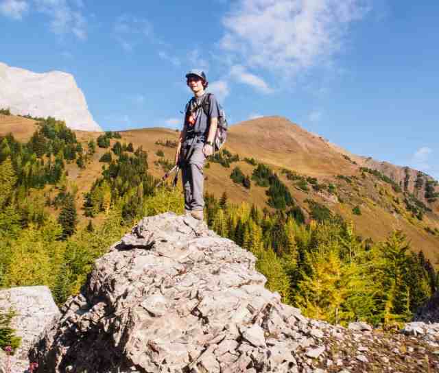


As usual, I was at the back of the pack. Although not quite as steep (and definitely not as long) as the climb up Mount Lady MacDonald, the hike from Pocaterra Cirque to the first peak along Pocaterra Ridge is a decent workout: 250 meters elevation gain in just over 1 km. I kept looking around for things to distract me from my own heavy breathing and one of the most interesting things I spotted was the “face” made up of three small caves on the shoulder of Mount Tyrwhitt that comes down to Little Highwood Pass. I think it looks a bit like a buffalo face. What does your imagination see?


The first of four peaks along Pocaterra Ridge is about 4.5 km from the parking lot and sits about 500 meters higher. We stopped there for lunch and to take some photographs.


Two other groups stopped to chat with us at this point. They were continuing along the ridge to the Little Highwood Pass Day Use parking lot. We opted to turn back at this point, as we hadn’t arranged for a shuttle to get back to where we parked our vehicle.
A few things of note about our return trek:
- We passed about 40 people on the way up – the most we’ve ever seen in this area!
- As we passed one of the biggest boulders in the cirque, we could hear a family talking. The little boy was insisting that “the GPS says it should be right here” while the Dad commented that “it’s more likely over there.” It was pretty easy to figure out that they were looking for a geocache we placed back in 2008, so I wandered over to play a little game of “hotter / colder” with them. They’ve just started geocaching and they haven’t yet logged their find and since the little boy answered with his first name when I asked what their geocaching screen name was, we may never know anything more about them. But it was still an interesting coincidence.
- Mr. GeoK and I stopped at the small waterfall just downstream of the tarn to make use of the ND filters we’d packed along. After just a few shots, we called it quits and carried on. At this time of year, the falls aren’t very impressive. Here’s the best of the lot…

We were back at the parking lot by about 1:30. Every parking spot was full and vehicles were parked along the edge of the narrow connector into the parking lot, along the edge of the highway and anywhere else they could squeeze a vehicle into. A lot of folks must love this area as much as we do!
SUMMARY:
Total hiking distance = 9.0 km
Net elevation gain = 500 m
Total hiking time = approx. 4 hours (about 2 1/2 hours for the ascent and about 1 1/2 hrs for the descent)
For end-to-end along Pocaterra Ridge (which requires a shuttle arrangement or hitchhiking to collect your vehicle), the total hiking distance is 12 km. Although the net elevation gain is still 500 meters (if you start from the Highwood Meadows end), the total elevation gain is almost 1300 meters, as the ridge drops down and then climbs back up to at least 4 peaks along its length. Back in 2006, it took us about 7.5 hrs from start to finish. And look how much the GeoKids have changed since then!

We’re planning to return to the Highwood Pass area at least a couple more times this fall. What about you? Both Pocaterra and Arethusa are great spots to see golden larch trees (and they’re not as busy as Larch Valley)!