
Generally speaking, we’re fair-weather hikers. But when Environment Canada’s forecast shows nothing but rain, chance of showers and/or risk of thunderstorms for the next seven days, we become a lot more receptive to the idea of a half-day hike where we might encounter some precipitation on the way back down.
All of which is a roundabout way of explaining why, early on a Friday morning in late July, we exited the TransCanada highway at Dead Man’s Flats and headed south on George Biggy Sr. Road to the parking lot for Skogan Pass, Wind Ridge, Mt. Allan Centennial Trail (north approach) and our objective for the morning – Pigeon Mountain.
NOTE: The Pigeon Mountain Trail is closed from December 1 through June 15 each year, to provide the large population of Rocky Mountain Bighorn Sheep lots of room to range and an undisturbed calving season.
Skogan Pass Trail
To reach Pigeon Mountain requires putting up with the relatively boring (but easy) first 5 km of the Skogan Pass Trail. On the way up, we opted to follow the power line right-of-way access road, which roughly parallels the power line. Fortunately, a few different things broke the monotony: we came upon a mule deer beside the trail, we had to keep a close eye out for bears and we found a couple of geocaches hidden just off the path.


Pigeon Mountain Trail
About 5 km from the parking lot, after the road turns a bit north from the power line right-of-way and goes through a couple of wide switchbacks, there’s a trail intersection. The narrow dirt trail up to the left is the Pigeon Mountain Trail (there’s a wildlife information sign here), while the Skogan Pass Trail carries on towards Nakiska.
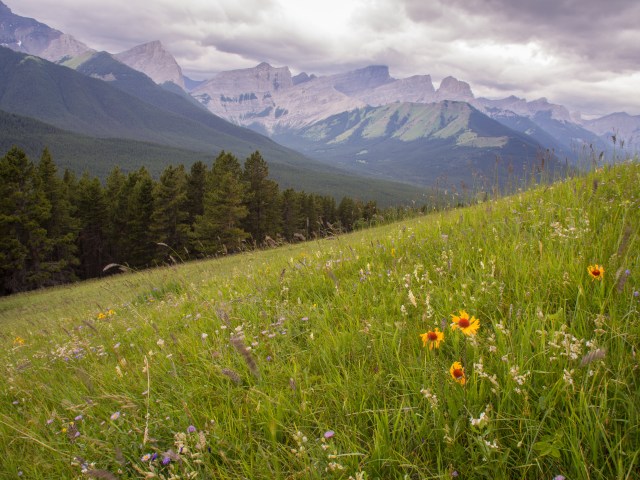
Within 10 or 15 minutes we reached treeline, facing the narrow end of a grassy wedge that reaches down from the South (false) summit of Pigeon Mountain. This is a good place to stop for a snack, and – if it’s windy – dig out another layer of clothing and tighten your hat!
From the treeline it’s a steady climb up through the tall grass and wildflowers, with the rocky outcropping of the South summit high above. Although we hiked Pigeon Mountain on a cool and blustery day, the rain held off and the clouds added some drama to the sky above the Bow Valley. Brown-eyed Susans, Fireweed, Scarlet Indian paintbrush and other wildflowers were in bloom and we took full photographic advantage.


Despite extremely strong wind gusts (my trekking poles would move a little bit sideways every time I moved them), we stopped several times up top. We found 2 more geocaches here, including one near the summit cairn. About 500 meters along the ridge past the North (true) summit we finally found our paramount geocaching objective of the day – a survey marker that’s one of the published locations for one of our all-time favourites – GC43F3 – Brass Cap Cache. Collecting the information required to log this particular survey marker as “found” brought our geocaching total for the day to six successful hunts.

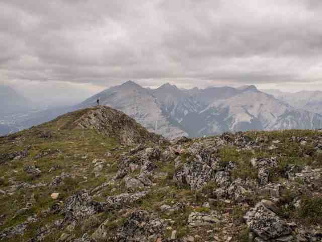
Despite wearing every article of clothing that we’d packed, we were both growing chilled by the time we reached the survey marker. So from there, we made a quick dash back towards the treeline. We made the mistake of dropping down from the ridge (on the west side), hoping for shelter from the wind, but it took us considerably longer to work our way across the extended talus field and we didn’t find any respite from the wind. In hindsight, it would have been better simply to retrace our ascent route as quickly as possible.

As we neared the end our trek back down the grassy slope, we spotted another pair of hikers emerging from the treeline and beginning their own battle against the wind. Imagine our surprise when they turned out to be friends of ours from Calgary. We hadn’t seem them in a few years, so we had a bit of a chat and then parted ways. It was yet another reminder that it’s truly a small world!

Once we reached the Skogan Pass Trail we opted to follow the cutline instead of the road, which turned out to be a mistake. The road is relatively level, whereas the cutline involves crossing a couple of steep draws and a small creek crossing. In our experience, it’s better to stick to the road.
SUMMARY:
Total hiking distance = 16.5 km
Total elevation gain = 1062 meters (993 net)
Hiking time = 5 hrs including several short stops for photography and to search for geocaches
This would be a good early summer conditioning hike and would also be a good option in the fall. From the ridge there are great views all along the Bow Valley and a remarkable panorama of mountain peaks. If you like solitude when you’re out hiking, it’s surprisingly uncrowded compared to more popular Canmore area hikes (Ha Ling, Grassi Lakes, Lady MadDonald, Heart Mountain). From all the online trip reports we’ve been able to find, it’s pretty much always very windy up top, so be sure to take one more layer than you think you’ll need!
Pingback: Hiking the Bow Valley – Wind Ridge | Out and About with the GeoKs
Pingback: Hiking Banff NP – C-Level Cirque | Out and About with the GeoKs
I’d like to hike with you! Could you move all trails closer to NYC? 😉
Ha ha! Wouldn’t that be an amazing ability? #ParallelUniverse
I believe in you! 😉