
Highlights from our paddle around Upper Kananaskis Lake include beautiful reflections, an island stop and a chat with another kayaker. We paddled 15 km (9 miles) in four hours, with a boost from whitecapped waves pushing at our stern as we returned to the boat launch.
Getting There
We drove HIghway 40 south, turning onto Highway 742 at the winter gates in Peter Lougheed Provincial Park. Two cars were parked at the winter gates. That number increased to hundreds of vehicles along Highways 742 and 40 by early afternoon because it was the last day to cycle Highwood Pass before it opened to vehicles for the 2021 hiking season.

We opted to park in the Upper Kananaskis Lake Day Use area, near the boat launch. The other option would be the Interlakes parking area (no boat launch). Arriving a few minutes before 7:30 am, we were the fourth car in the lot. NOTE: starting June 2021, you need to purchase a Kananaskis Conservation Pass to park anywhere in Kananaskis Country.
Because we had a lot of space, we opted to spread our tarp right behind our car, and inflate/set-up our kayak in the parking lot.

It worked really well, and saved a bit of time because we didn’t have to haul our crate of gear down to the lakeshore and then haul the pump, tarp, etc. back to the car. And we confirmed that 15 minutes to set up at Two Jack Lake was not a fluke!
Heading Northeast (Counterclockwise)

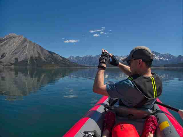
We headed out to paddle counterclockwise, mainly so that we wouldn’t be shooting photographs directly into the sun. It worked really well. We got a ton of amazing mountain reflection photos as we paddled along, keeping the shore fairly close off our starboard (right) side.


Approaching the Channel to Interlakes
Approaching the inlet to the channel to the Interlakes parking area, we spotted another kayak! It was a new-to-us variety, powered by pedaling. An hour or so later, we ended up chatting with Brian – a conversation that led to a photo swap. And Mr GeoK is busy researching Hobie kayaks, with a view to doubling our fleet at some point! 😉

Further down the channel to the Interlakes we spotted some TransAlta infrastructure – a visual reminder that Upper Kananaskis Lake is the result of a manmade expansion of a natural lake. A minute of research back at home revealed it’s the Interlakes Hydro plant, one of TransAlta’s smallest power plants at just 5 MW.

Stop at Hogue Island
Without a drone (not permitted in Alberta’s provincial park, nor Canada’s national parks), it’s pretty tough to get a photo of yourself kayaking. So Mr GeoK packed a tripod, thinking we’d find a deserted stretch of shoreline to set up a time lapse of us paddling. Reality was better! We stopped at Hogue Island – one of two islands to survive the damming of Upper Kananaskis Lake (more details on the lost islands and the islands’ names here).

While Mr GeoK set up the tripod and iPhone to record a time lapse, I checked out some of the tree stumps created when clear cutting was done before the newest dam raised the lake level.

Knot detail in weathered stump 
Weathered stump tree ring detail
I also took a photo of Mt Indefatigable with the camera half submerged in the lake.

Once the camera was all set up, we climbed back aboard and kayaked in and out of the frame. Here’s a snippet from the timelapse.
Another snippet is included in Mr GeoK’s Relive video recap of our kayaking Upper Kananaskis Lake adventure.
When we pulled back ashore to retrieve the tripod and phone, I couldn’t resist this shot of blue water, blue sky, puffy white clouds with a red kayak.

Hawke Island and Point Campground
We paddled right on by Hawke Island, opting to save a stop here for our next outing on Upper Kananaskis Lake.

Continuing towards the head of the lake, we spotted a stump graveyard along the eastern shore. With a small, hard-sided kayak and somewhat higher water level, this could be an interesting skills course.

As we passed Point Campground, we spotted a couple of kayaks pulled up on the rocks below one of the tent spots. As well, two campers were hanging out along the shoreline.

Abrupt Turnaround
Just after our pass by Point Campground from the main lake, we spotted the pedal kayaker coming out of the channel that leads to the outlet of the Kananaskis River into Upper Kananaskis Lake. We chatted a bit and got his email address so we could send him some photos. And he reciprocated! 🙂
In addition, he advised that if we had the time, paddling down the channel to see the Kananaskis River flow into the lake was worth the detour.

The water in the channel was more turbid (opaque due to silt/dirt particles) – not a surprise during spring melt.
Then, as we paddled along the eastern row of tent sites at Point Campground, a sustained wind gust blew in, rippling the water. We made an abrupt 180 turn and started back towards the boat launch, aware that the day’s forecast called for winds up to 50 kph by early afternoon.

Return to Launch
From turnaround back to the boat launch we moved at a pretty steady clip, averaging 5 kph (vs 4.4 kph moving average speed to our turnaround point). But we did slow a few times, turning the kayak to look behind us to the storm clouds popping up.


Looking forward, ripples came and went. At one point, the ripple line converged with the reflection of the Pocaterra Ridge line.

Last Stop
Our final pause before returning to the boat launch was at the outlet of Sarrail Creek Falls. We first had to navigate between a fly fisherman on the shoreline and a fly fishing boat (which lead to a shouted conversation about how far they could cast).
Anyhow, I did my best to hold the kayak relatively steady while Mr GeoK got the shot.

By this time, the wind was a little more steady. And during our last 10 minutes of paddling for shore, we were chased by whitecaps. A couple of other kayakers near the shore gave up paddling and let the waves sweep them towards the beach.

After nosing safely into the shore, Mr GeoK did get wet after losing his balance while disembarking. The alternate version is that I paddled a stroke just as he climbed out. Whatever happened, he got pretty wet. So note to self: leave a change of dry clothes in the car. Also, one benefit of being the one in the rear seat is that I get to climb in first and out last, so there’s a person holding the kayak steady, rather than a paddle.
Summary
Total paddling distance: 14.8 km
Total time: 4 hours, including 45 minutes for snacks and photography
We’d definitely kayak Upper Kananaskis Lake again, next time with a stop at Hawke Island and with the aim of seeing where the Kananaskis River outlets into the lake. But only on a calm day. This lake is large enough that we’d be concerned about high waves on a windy day.
Epilogue
After safely passing through the hundreds of cars parked on either side of Highways 742 and 40 (cyclists riding Highwood Pass), we spotted two blondish grizzly bears further north along Highway 40. A short pause to grab a couple of photos and we continued home.


Pingback: Make Your Month Different - Out & About with the GeoKs
Pingback: Water - Out & About with the GeoKs
Pingback: Kayaking Lake Minnewanka - Out & About with the GeoKs
I look forward to reading your posts and thoroughly enjoy your photos! The perspective from a kayak is so different. Tthe reflection pictures are stunningly beautiful. Your accompanying text is really interesting and captures the thought process behind each shot. Love this!
Fabulous photos! I must get there soon. Check out my adventure today on Relive!