
Mr. GeoK crash landed his mountain bike last July. His resulting injuries meant we didn’t get out hiking again until September. So when we started thinking about where to go for our first big family vacation since 2011, one of the key decision points was that it had to be somewhere we could go hiking – someplace like New Zealand!
Our first New Zealand hike was a guided excursion up Single Cone in the Remarkables, a mountain range (and downhill ski area) just outside of Queenstown. The whole guiding thing is unusual for us. More typically, we do our pre-hike research, route planning, pack appropriately and head out on our own. But we knew in advance that Single Cone would be out of our comfort zone. Fixed anchor points, harnesses and ropes would be involved in ascending the final 200+ meters and for the first part of the trip back down. And since we’d never done any of that before, guides seemed like a good idea.
Our chief guide Chris, from Independent Mountain Guides, met with us the night before. He wanted to check out our boots and other hiking gear (and he no doubt wanted to check out our general level of fitness, as well). Then he headed off to rent helmets and harnesses for the four of us.
At 8 o’clock the next morning, Chris and our other guide, Tarn (who is also Chief Guide for Southern Lakes Heliski), arrived to pick us up for the 45 minute drive to the parking lot at The Remarkables ski hill. I learned some interesting things along the way. First, Tarn has guided all over the world, including Antarctica, Europe and Canada (at Yamnuska, just east of Canmore (where we spend as much time as possible)). Second, he had a mountain biking accident just a week or two ago and he would be abseiling two of us with two broken ribs (he is one tough-minded guy). And third, the road up to the ski hill is a lot like the Smith-Dorrien “highway” between Canmore and Kananaskis Lakes; in other words, a curving, hilly, gravel road that kicks up lots of dust!

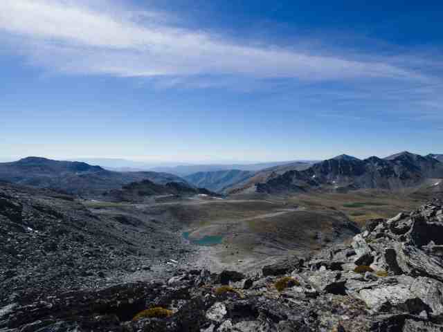
We hiked along a construction road for a bit; the ski area is expanding. (In fact, on our way back down we heard someone yell “fire in the hole” and then a big “thwump” as a stubborn chunk of rock was blasted away.) Then we made our way along a well-established track through some boggy areas with a good range of vegetation, much of it new to us. The terrain grew drier as we slowly gained elevation. Then we arrived at Lake Alta. If you’re a big fan of the Lord of the Rings movie trilogy, you might recognize this area from the scene where Aragorn leads the fellowship down the steep slopes of Dimrell Dell.

After a short pause to take some photographs, we began picking our way through stone rubble, rocky schist outcrops and the occasional patch of scree. The black and white striped blocks of rock reminded me of the “zebra rocks” we’ve seen upstream of the Headwall Lakes in Kananaskis Country. The trail isn’t particularly visible, but you’re headed to South Wye Saddle, a very obvious landmark. By the time we crested the saddle, we’d gained about 350 meters elevation and were ready for a short break.


The other thing we noticed here was that Chris and Tarn were re-applying sunblock – for the second time since we’d left the parking lot. That should have clued us in to renew our own sunblock, but it didn’t (we were all at least a little sunburned by the end of the day).


The boys partnered up with Chris. Tarn was stuck with me and Mr. GeoK. Chris went first and once he’d secured the ropes to the first fixed anchor point, the boys worked their way up behind him. As they were making their way up to the second anchor point, the rest of us started on the first section of the chimney.
 near the second fixed anchor point")


Past the second fixed anchor point, we worked our way around an outcropping and across a short, narrow section (which kind of freaked me out) before arriving at a nice wide slab of rock just below the summit. The boys were already at the very top when we arrived.


We had a nice break up top, long enough to eat lunch, take lots of photographs and find a geocache just below the summit.

Then it was time to learn a new skill as we headed back down – abseiling! It’s not as easy as it looks on TV and I have a good deal more sympathy for contestants in the Amazing Race who are faced with a rappelling task. Again, the boys went first and we were careful not to chuckle when they called out things like “lean back” or “Stop – I’m upside down in the snow” because we knew they’d be watching us from the bottom.


The boys were pretty glum when we joined them at 2100 meters. We soon learned that in the process of helping his big brother retrieve his camera from his pack, K dropped his brother’s Patagonia Nano Puff jacket, which bounced once, twice and then popped up over a rock and disappeared. Stowed away in its zippered pocket, there was nothing to slow it down and Chris confirmed it had dropped over the edge, some 100+ meters down to somewhere in the rocks below. K felt so bad and C was pretty mad, so there wasn’t much chatting after we tucked our harnesses away and started back down towards the tarn.
Once we reached the tarn, Mr. GeoK decided to drop his pack and set out to search for the jacket. As lead guide, Chris had no choice but to join him. Meanwhile, the rest of us continued on towards the parking lot, at a pretty quick pace.


We waited at the parking lot for about 45 minutes before they rejoined us. They only spent 20 minutes or so searching for the jacket, but they also stopped to cool off at Lake Alta and to chat with some other folks they ran into on the trail. Meanwhile, we were clamouring to know whether they’d found the cliff-jumping jacket – and they did!!! There were smiles and words of thanks and congratulations all around. It was a great ending to an altogether great day.
SUMMARY:
Total hiking distance = approx. 14 km
Net elevation gain = 819 m
Total hiking time = 6 to 8 hours
This is a challenging hike, requiring a good level of fitness, a good level of comfort with heights and sharp drop-offs, and the proper equipment and skills. Chris told us a couple of times about how he’s had to help experienced scramblers down from the summit when they found themselves stuck up top without any abseiling gear and/or experience. If you’re not fully confident in your experience, skills and equipment, we happily recommend that you contact Independent Mountain Guides to book one of their guides.
Pingback: Hiking Iceland: Fimmvörðuháls | Out and About with the GeoKs
Pingback: Updated Gear Review: Peak Design’s CapturePRO Camera Clip and Accessories | Out and About with the GeoKs