
With just over a month to go before we escape to Lake O’Hara for four days of hiking, the knowledge that Mr. GeoK routinely doubles my step count each day is starting to niggle away at the back of my mind. It’s not that I’m out of shape…more that I’m not in hiking shape – something easily rectified by getting out for longer distances with a loaded pack. I kicked-off my conditioning for the 2018 hiking season by inviting a friend to join me on a walk through the Ann & Sandy Cross Conservation Area, located just outside Calgary’s city limits.
Getting There
According to Google Maps, the usual time required to travel the 35 km from our house in Calgary to the parking lot at Ann & Sandy Cross Conservation Area is 37 minutes. Between rush hour traffic and multiple construction zones, my actual travel time was just over an hour. Once the southwest portion of the Calgary ring road is completed in 2021, it’ll be fairly, short easy drive. The key piece of information? Turn south onto 160th Street off Highway 22X (just south and west of Calgary). Once on 160th Street (which is paved), it’s short, straight run to the grave led parking lot.
About Ann & Sandy Cross Conservation Area
Established in 1987 when Ann & Sandy Cross donated of almost 2000 acres of land to the Province of Alberta, the area was expanded to 4800 acres when Ann & Sandy Cross donated another 2800 acres in 1996. The property protects habitat, provides space for native species of wildlife and offers conservation education programs (primarily to youth). It’s not a park, but a conservation area, so has specific guidelines that all visitors are required to follow, including no dogs and no bikes.
A welcome/registration kiosk sits at one corner of the parking area. All visitors are required to register their vehicle and the number of hikers. At the time of writing, groups of 15 or more hikers are required to pre-book their visit.

Guidelines are posted at the kiosk. There is also a large trail map. Printed maps are available by donation. Visitors are encouraged to leave a donation to support the work of the foundation and volunteers which steward the land.
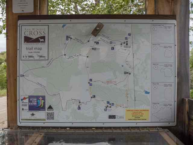
Exploring the Trails
After stopping to use the plumbed bathrooms, my friend and I head out on a counter-clockwise loop that started with the Mountain Trail. We stopped briefly at the tipi set up behind Belvedere House (administrative and classroom space), and a couple of lookouts.

For a few minutes, a puddle of sun broke through the heavy cloud cover.

From a couple of vantage points, there’s a pretty nice view of downtown Calgary, more than 10 km distant to the northwest.

At a well-signed junction, we turned onto the Fescue Trail for a short distance, before turning onto the Aspen Trail at the next trail intersection. It’s appropriately named, traversing some lovely stands of aspen.

We spotted several kinds of wildflowers in the woods, including heart-leaved Arnica, white violets and blue clematis.
At the next trail junction we opted to turn onto Paradise Trail, which is the longest trail open to the public. We stopped at West Side Lookout for a mid-morning snack, about an hour after setting out. Thanks to heavy, low cloud, our view was limited to the rolling foothills. I imagine the Canadian Rocky Mountains look pretty impressive on a clear day.
 Between West Side Lookout and reconnecting with a different section of the Fescue Trail, we spotted a couple of picnic tables – which I’ll keep in mind for next time.

With the cloud cover restricting views, our attention was drawn to the wide variety of vegetation and many shades of green.

We smiled at the low sign indicating we’d arrived at Bear Valley.

We didn’t see any bears, but we did see a pair of mountain bluebirds in this valley. 🙂

It wasn’t until we were back on the Fescue Trail that we saw any other people, first a group of five asking about any wildflowers we’d spotted, then a lone walker, and finally a class of school students with their teacher, chaperones and staff from the Conservation Area.
We stopped at Pine Creek Lookout, which overlooks the area where Connect Charter School (formerly Calgary Science School) students made field observations related to a beaver reintroduction program starting in 2012. I was a parent volunteer on three of those trips: June 2012, October 2012 and June 2013. This area is not open to the general public. Next visit, I’ll try to remember to stop at Belvedere House to ask how the beaver reintroduction is going.
We finished our loop and claimed one of the picnic tables near Belvedere House, where we sat visiting, enjoying our packed lunches, taking in the views and listening to birdsong – a relaxing end to a gentle warm-up hike. 🙂
I put a pretty full load in my pack, including rain gear, camera gear, plenty of water, bear spray, first aid kit, toque (which I needed) and packed lunch. The only after effect of note? Stiff shoulders/neck for a couple of days, which served to remind me that it’s better to use a pack with an effective waist belt, to transfer some of the load onto the hips.
Summary
Distance = 8.9 km (with shorter/slightly longer options)
Total elevation gain = 298 meters (120 net)
Total time = 3 hours, including 20 minutes for a snack break and several short photography stops (but excluding lunch)
Would I do this hike again? Yes! It’s a quiet, easy half-day outing that will be quick and easy to access once the Calgary ring road is complete. A spur-of-the-moment trip to enjoy blue sky and mountain views would be great. And a trip planned to take advantage of Calgary’s brief period of fall colours would also be a good option. Next time around, I will also collect the information to solve a multicache that uses information signs throughout the property to solve for the final coordinates.
Have you explored Ann & Sandy Cross Conservation Area? If so, what did we miss that I should be on the lookout for next time?
where is my mom’s tree planted Linda Ethel CHiniquay
What a lovely way to remember your Mom, and in a lovely setting.
Pingback: Photo Blogging Challenge – Fun (June 2018) | Out and About with the GeoKs