
As first-time visitors to Death Valley National Park, we seriously underestimated the scale of America’s hottest, driest and lowest national park. Better pre-trip research would have revealed that Death Valley NP is the largest national park in the lower-48 and resulted in a more realistic plan. Instead, we set ourselves up for a 13-hour day-trip from Las Vegas that covered barely half our itinerary. So for us, any future return visit to Death Valley NP will include an overnight stay in the park, for more boots on the ground/less driving time, plus opportunities for sunrise and night photography.
Our Day
On the Road
We left our Las Vegas hotel around 7:30 am. Between a stop for groceries and the 2 hr + drive time, it was mid-morning by the time we turned on to Dante’s View Road.

The strange-to-us vegetation prompted a couple of short photo stops.

Then we spotted what looked like abandoned hotel buildings up the side of the hill and some idle heavy equipment around the next corner. Based on research done after our vacation, these are some of the above-ground remains of American Borax Company’s Billie Mine, which operated until 2005.


Billie Mine wasn’t on our list of planned stops for the day, so we didn’t spend a lot of time exploring the photographic potential of this site, which is located just outside the Death Valley NP boundary.
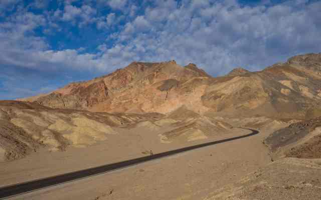
Continuing towards Dante’s Peak, the road becomes increasingly narrow and curvy. At one point we passed a pair of cyclists – one on a road bike, one on a mountain bike – a sight that triggered feelings of admiration, and commiseration for the mountain bike rider.

Dante’s View
Apparently it was about a hundred years ago that Pacific Coast Borax officials named Dante’s View, inspired by descriptions of Dante’s Purgatory. While there’s definitely a starkness to the landscape, in late January, under a blue sky, there’s also a unique beauty.

We spent well over an hour exploring boot-beaten trails cresting the low peaks of the Amargosa Range.


Some of that time was spent with a 300 mm (600 mm equivalent on full frame) lens, looking down at details in Badwater Basin.

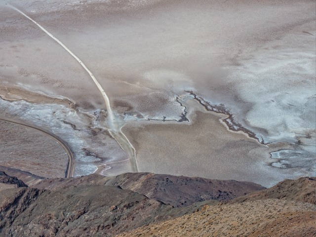


In hindsight, it turned out to be a good thing that we spent a fair bit of time examining Badwater Basin from Dante’s View, because we ran out of time to explore it on foot!
Zabriskie Point
For almost 50 years, beginning in 1885, Christian Brevoort Zabriskie had close connections to Death Valley. Early on, he supervised hundreds of Chinese workers in Pacific Coast Borax mines. With the end of borax mining, he had a key role in the process of changing Death Valley from a mining area to a natural monument and tourist attraction.

Zabriskie Point is quite dramatic under harsh midday sun. Depending on the direction you’re looking, there are no shadows or deep shadows. On any future return trip, we’d plan to be at Zabriskie Point for sunset or sunrise photography.

The landscape here reminded us of Alberta’s badlands, including Dinosaur Provincial Park near Drumheller and hoodoos in the Canmore/Banff National Park area.

Furnace Creek Visitor Center
One essential stop during our first visit to a US National Park in years was the Visitor Center, to purchase an annual pass for US$80. That was a bit of a calculated purchase for us, because paying separate admission to Death Valley (US$30) and Grand Canyon ($35) would have cost less than the annual pass. But we figured the extra $15 was a reasonably-priced option for a no-charge visit to other national parks/monuments during our early 2020 vacation plus maybe a shorter US getaway in the fall.
Anyhow, we got our National Park pass, a park map and a photo of the broken thermometer, which read just under 100F (our car thermometer showed 78F as the highest temperature of the day).

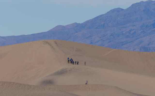
Mesquite Flat Sand Dunes
Road construction project along a stretch of CA-190 extended the drive time to/from Mesquite Flat Sand Dunes. But it was definitely worth going – even though it was pretty much impossible to find a stretch of sand dunes untouched my human foot steps!

Three things broke up the undulating dunes: 1) mesquite trees/shrubs (dead and alive); 2) cracked, dry-mud areas in some of the low areas between dunes; and 3) lines of people climbing distant dunes.


Persistence eventually paid off with a small section of undisturbed dune. By kneeling and framing a composition that basically looked up the approx. 10 foot slope towards the sky, this image leaves the size of the dune to the viewer’s imagination.

As we worked our way back towards the parking lot, I spotted a shirt and pair of shorts/pants carefully laid out on the sand. While they introduced an element of surprise to the landscape and this photo, they don’t belong. Is the person who left them out walking the dunes in their birthday suit and planning to return? Are they litter? How long until they’re covered by sand? If clothes could talk, I’d like to hear the story they would tell.

Running out of Daylight
By the time we left Mesquite Flats, it was late afternoon and we still hadn’t hiked Mosaic Canyon, driven south into Badwater Basin to stop at Devil’s Golf Course and hike from Badwater out into the basin, nor driven the one-way Artist’s Drive. After considering possible driving routes back to Las Vegas, we opted to make Artist’s Drive our last stop for this trip into Death Valley.
Artist’s Drive and Palette
Artist’s Drive in a one-way loop road accessed at the south end of the loop, off Badwater Road. The badlands at Zabriskie Point hint at what this landscape is like, with the key difference being the variety of colours in the exposed rock.
We arrived at Artist’s Palette about half an hour before sunset, so had lots of time to jostle for spots among the surprisingly large group of photographers who’d already staked positions with their tripod-mounted cameras. We opted to split up, with Mrs. GeoK on a rise on one side of the parking lot and Mr. GeoK on the other.


Departing Artist’s Palette, we soon realized why the road is only one lane – it was a tighter path through narrow gullies than even the much-photographed White Domes Road in Valley of Fire State Park that we drove the following day!
Our day trip to Death Valley NP from Las Vegas took more than 13 hours, including 621 km (386 miles) of driving time. Our favourite stop was Dante’s View. We covered just over half the sights we’d planned to visit and had to skip our planned hike into Mosaic Canyon. In addition to spending time in Badwater Basin, doing at least one hike and sunrise/sunset plus night photography, we’re open to recommendations for a possible return visit. Ideas?
NOTE: We traveled to California, Nevada and Arizona in late January/early February 2020, many weeks before WHO declared COVID-19 a pandemic. For me, one way of coping with the potential overwhelm of 24/7 “more bad news” coverage is to spend time every day focusing on something else – like writing, a photography project or something else that occupies mind and hands. For once, our usual time lag between being on vacation and writing about it is a plus – a ready-made backlog of new posts to write. 🙂
Pingback: Out & About with the GeoKs - Las Vegas to Phoenix Vacation
Pingback: Out & About with the GeoKs - Day Trip: Wupatki National Monument
Pingback: Out & About with the GeoKs - Day Trip: Grand Canyon South Rim
Pingback: Out & About with the GeoKs - Day Trip: Valley of Fire State Park