
Albertans continue to #ditchinsideforoutside. Every time we drive past the turn-off from the TransCanada onto Highway 40 into Kananaskis Country, there are vehicles lined up on the exit ramp. There’s almost no snowshoes, cross-country skis, snowboards, downhill skis, avalanche equipment, snow boots and other winter gear in stock at MEC’s downtown Calgary store. And we’ve heard from friends who are having a hard time finding winter recreation paraphernalia!!
We also continue to get out and about, almost every day. In past years, we’ve mostly stuck to trails in Calgary and Canmore. But with so many folks out and about, we’re finding those pathways to be quite busy, even when we head out before sunrise.
So we’ve been looking to Canada’s Rocky Mountain national parks and Kananaskis country for other winter hiking options. However, we do not have AST1 training. With limited avalanche awareness skills (a few online webinars, including Avalanche Canada’s online Avy Savvy tutorial), we carefully screen for simple avalanche terrain (i.e. low risk, below treeline, few to no avalanche chutes, etc). We refer to Parks Canada’s winter trail recommendations and Alberta Parks’ snowshoe and cross-country ski trail resources. And we check Avalanche Canada’s latest bulletin. And we follow our usual safety routines – pack emergency and first aid supplies, let someone know where we’re going, when we expect to be back, and carry a GPS receiver with satellite messaging capabilities.
Despite all those screening criteria, we’ve already found several new-to-us winter hiking/snowshoeing areas including Boom Lake and Taylor Lake. We’ve also spent a couple of half days hiking in the former Yamnuska Natural Area, now part of Bow Valley Wildland Provincial Park. Spoiler alert: if we hiked the south end of this area first, we never would have returned – it’s our worst hiking experience so far!
Getting There
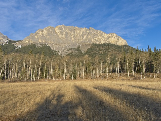
The Yamnuska Natural Area sits just below Yamnuska, Loder Peak and Door Jamb Mountain, bounded on the other side by Highway 1A. We accessed this area via the Highway 1X exit off the TransCanada Highway a few km west of the Highway 40 turnoff into the Kananaskis Valley. There are a few parking options, including the main parking lot for Yamnuska and another parking lot on the south/west side of Highway 1A across from the turnoff to the Francis Cooke Class III Regional Landfill. Other parking options are along the highway. Recommended resource: Gillean Daffern’s Kananaskis Country Trail Guide Volume 3. A highly condensed version of the area trail descriptions appears on the Daffern’s Kananaskis Trails website.
Key fact – all the trails in this area are unofficial, so there is no trail signage. Our usually helpful GPS maps do not include any trails for this area. Consider downloading a map from AllTrails or bringing a copy of the map from the Daffern’s guidebook/website. Even with a paper copy of the map, we had challenges with route finding, especially where the trails were snow-covered. This screengrab from our GPS map software shows our two half-day routes:

North Loop
For those who prefer, here’s Mr GeoK’s Relive video recap of our first hike in this area.
Beaver Dam Lakes
We parked in the main Yamnuska parking lot slightly before sunrise on a late November morning and immediately headed for the Beaver Dam Lakes with the aim of photographing the sunrise as it hit Yamnuska.

Loon Lake
When nothing materialized, we carried on to Loon Lake, where we finally caught some sunrise colour.


Off Trail to Meadow Lake
Satisfied we had at least a few decent sunrise photos, we opted to head through the woods to Meadow Lake. To navigate, we referred to a geocache we had loaded in our GPS unit – one we knew from advance research was hidden close to Meadow Lake. Then we followed the sightline. By the time we’d made our way up and over a glacial moraine, dodging windfall and skirting low shrubs, golden hour was in full swing.

After making a relatively quick find of the nearby geocache, we headed south along the boot beaten trail.
Golf Course
The “golf course” refers to a wide, grassy meadow that resembles a fairway. It’s lined by aspen woods on one side and mixed forest on the other. We made note of the location, as this would be a lovely spot to search for wildflowers in the summer and to photograph aspen trees in fall.
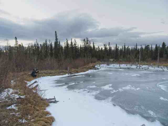
Beaver Pond
While generally heading for Crescent Lake, we opted to make a short detour to another Beaver Pond. Here, tree stumps stood above the ice and below Yamnuska. And there were some cool methane bubbles in the ice, too.


Crescent Lake
The main track in the unofficial trail covers about a quarter of the Crescent Lake shoreline. But thanks to a prolonged, early cold snap, the lake was thoroughly frozen. We took advantage of the ice to circumnavigate the entire lake in a clockwise direction – mostly on ice, but partly on the main track where we made another geocache find. 🙂


Hilltop Pond
Our next photostop was Hilltop Pond, where a small patch of reed grass and ice bubbles caught my eye. NOTE – on our second half day hike in this area, about 6 weeks later, the reed grass was gone. Based on tracks and scat in the area, some deer enjoyed a tasty meal. 😉


Return Trek
From Hilltop Pond, we took a quick look at Reed Lake. (No photos, as we would have been shooting straight into the sun. Plus the shoreline is a jumbled mess of fallen trees.) Then we spent some time casting about for a route that would take us across a meadow, curving north back towards parking.
There was extensive flooding across the well trodden path and we could see and hear water flowing below a fairly thin layer of ice. Eventually we opted to pick our way through the stand of aspen trees on the north side of the flooded area. We discovered it’s been flooded long enough that other hikers have constructed a makeshift log crossing over the creeklet flooding the field.

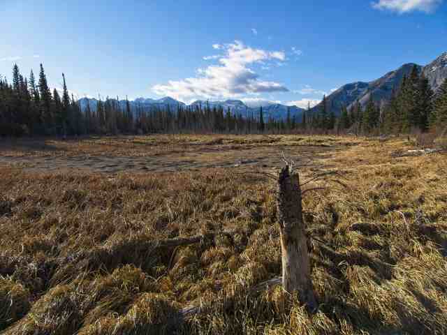
Safely past the obstacle, we made our determined way back to the parking lot, stopping once to photograph the “Great Swamp” (dry at this time of year) and to find one last geocache.
SUMMARY:
Distance = 13.8 km with a total elevation gain of 393 meters. We were out for about four hours, including multiple stops for photography and four geocaching stops.
South Loop
After a dump of snow a few days before Christmas, we enjoyed an extended period of above average temperatures, with daytime highs mostly above freezing. After a few long walks in Canmore, we were ready to get out and about on some new-to-us winter hiking trails. I talked Mr GeoK into exploring the south end of the former Yamnuska Natural Area. Here’s his Relive recap of our (mis)adventure.
Parking
It was an all around bad hiking experience, starting with having to ask for directions to the parking lot from staff at the office for the Francis Cooke Class III Regional Landfill! NOTE: it’s an unsigned lot directly across Highway 1A from the well-signed entrance to the dump.
Next, to access this part of Bow Valley Wildland Provincial Park, we had to run across Highway 1A. This stretch of road is used by double-trailer trucks hauling loads for the three nearby cement plants, by travelers taking the more scenic route and by outdoor fun seekers, including those looking to skate “wild ice” in the winter. Crossing is scary!
Along the Fence
Then the real fun began…hiking along the dump fence line for 20 minutes! Prevailing westerly winds meant dust, grit and the occasional piece of plastic kept flying towards us from the landfill. I later read in Gillean Daffern’s guidebook that she recommends bringing a couple of shopping bags to pick up garbage if hiking in this area.


At this point in our adventure, we followed a well-trodden path in the snow. From the track patterns, it looked like someone had snowshoed here shortly after the December 22nd snow event.

First Wrong Turn
Finally past the end of the fence line, we continued to follow the tracks, pausing a couple of times to try to figure out where we were based on the map I’d photocopied from Daffern’s guidebook. I’m pretty sure we made the correct choice at the first “Y” intersection. But we definitely made the wrong choice at the next “Y” intersection. We kept gaining elevation and then the track suddenly disappeared into patches of juniper and rock. We had good view over the Bow Valley from below Door Jamb Mountain and Loder Peak. And we eventually figured we might have been following the tracks of ice climbers headed here…

We opted to go cross-country, aiming for where we figured the big Douglas Fir, spring and two tiny pools should be. Again, we found a track that we followed for a while and then it simply ended!? And once again, we enjoyed good views while we decided what to do.

Hidden Valley
By this time, we’d been out well over half the time we’d notionally allocated, so we decided to head down into what we hoped was Hidden Valley. Turned out that was a good decision, becaused we found an established trail in the valley bottom.
Next decision: go back towards the dump? or carry on through Hidden Valley, past Crescent Lake and then back vie the powerline right-of-way. Hoping we were close to Crescent Lake, we opted to carry on.

We’d have been better off turning around. Crescent Lake looked much the same as it had several weeks earlier. The patch of reeds and grasses at Hilltop Pond had been eaten by some kind of ungulates since our last stop. Otherwise, it was a matter of one foot in front of the other…

Powerline Right-of-Way
The long walk on the powerline right-of-way was directly into the wind, with nothing to slow the sand-blasting effect of the grit coming off the dump. Even though our cameras are “weather sealed” we opted to stow our photo kit in our packs. And I was glad I’d opted to wear the same contact lenses I’d been wearing for two weeks rather than switching to a new set that morning. 🙂
SUMMARY:
Distance = 9.8 km with a total elevation gain of 350 meters. We were out for just over three hours.
Final Thoughts
We saw no one in the south part and only one other person while hiking the north part of Yamnuska Natural Area, so it’s definitely quieter than a lot of Alberta’s provincial parks during COVID times. There are lots of ponds/small lakes, so it’s likely a good area for birdwatching. One of the friends I told about this area went skating on Meadow Lake with her family.
We saw signs of ungulates and coyotes, squirrels and snowshoe hares. Also on the plus side, it’s relatively flat and there’s a handful of quality geocaches. With a fairly extensive trail network, there are lots of options for out-and-back and loop hikes of various distances.
But there are two BIG drawbacks. One applies to the entire area: the trails are not signed, do not appear on the Gemtrek map for the area (at least not the version we have) and are not in our GPS maps. Heck, they’re not even in Google Maps! This is less of a problem when there’s no snow on the ground, but route finding becomes very challenging when there’s snow cover.
The second big negative is the landfill at the south end. But that’s easily avoided. IF we ever go back to this area to finally find the big Douglas firs, spring and two tiny ponds, we will be sure to park at the main lot at the north end or in one of the two small pullouts along Highway 1A.
Have you hiked this area? What have we missed?
Pingback: Bow Valley Campground Winter Hiking - Out & About with the GeoKs
I enjoyed looking at the late fall pictures especially the one of “The curve of Crescent Lake.” That one was really nice.
Thanks for taking me to this place.