
The first time we hiked to Helen Lake was with our kids. The next time, Cirque Peak was covered in snow. Then we hiked to the lake again with relatively inexperienced hiking friends. So when we talked through possible hikes to celebrate our 31st wedding anniversary, we decided that another attempt to summit Cirque Peak was a fine example of the perseverance required to nurture a positive, long-term relationship.
Getting There
The Helen Lake trail head parking lot along the Icefields Parkway, opposite the Crowfoot Glacier viewpoint. It’s roughly 33 km north of the TransCanada-Highway 1 and Icefields Parkway junction (north of Lake Louise) and is clearly signed. There were maybe 10 vehicles in the parking lot when we arrived a few minutes before 8 am.
The Trail
Parking Lot to Wildflower Way
The forested front end of the trail climbs steadily from the parking lot. The trail is relatively wide, but protruding roots require at least some attention to avoid tripping.

For the first time this year, we noticed a lot of yellow branches on the spruce trees. And we’ve suddenly got the same thing happening to the spruce trees in our Canmore yard – anyone know what this is?

When we hiked the trail in late August, there were 6 small creek crossings in the first 1.5 km. These were easy to jump or rock-hop across (thanks to the hikers who moved the rocks into place).
The next thing of note is an avalanche chute (circa 2017/18, we believe) that provides a pretty good view of Crowfoot Glacier across the valley. Our experience is that morning light is better than afternoon light for photographing the glacier, so pause on the way up the trail if you like to photograph your hiking experiences.

The trail passes by the site of a small wildfire several years back and the dead, burned trees standing in new growth can also be interesting to photograph.
About 90 minutes from the parking lot, you’ll catch your first glimpse of Dolomite Peak between the trees. At this point, you’re just about at what I think of as Wildflower Way.

Wildflower Way to Waterfall
Emerging from the forest, the long stretch of relatively flat trail to the waterfall runs through meadows of wildflowers. This is some of the most impressive wildflower terrain we’ve seen, especially with Dolomite Peak as a backdrop on your right.

Even in late August, we spotted scarlet and fuchsia paintbrush, leafy asters, yarrow, heart-leaved arnica, yellow stonecrop, elephanthead and more. Morning sun makes it tough to come away with good wildflower photographs here. It’s better to create your photographic wildflower bouquet on the hike down – and it’s better to wait until afternoon to photograph Dolomite Peak, too.


About 1.5 km on, Wildflower Way ends at a waterfall where the trail crosses Helen Creek.

Waterfall to Helen Lake
There are a few obvious options for crossing the creek. The safest/easiest one is the most upstream. We paused here to take a couple of longer-exposure waterfall photographs and then continued along the trail through the upper meadow. Here, the wildflowers are less showy – but it’s a good area to watch for marmots. One time we spotted a grizzly bear along this stretch of trail.

In less than a km from the waterfall, hikers arrive at Helen Lake. Every time we’ve reached Helen Lake and there have been no hikers ahead of us, we’ve spotted a marmot near the shoreline. There was a marmot to greet us this day, as well, but it hustled off as the hikers behind us approached, music blaring from one of their packs.
Helen Lake to Cirque Peak
Helen Lake is three-quarters surrounded by higher land. The hiking trail continues along the right (east) side of the lake to the ridge behind. A switchback trail with a some big rock steps gets you to the top of the ridge. Even if you’re not planning to summit Cirque Peak, it’s well worth hiking up to the ridge to get a bird’s eye view of Helen Lake.

Working our way up to the ridge (and pretty much all the way to the summit) we played leap frog with the three hikers with the music (thankfully turned off out of consideration for the fact that we were well within hearing distance).
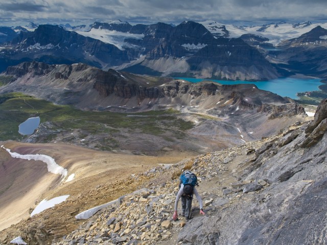
On reaching the ridge, we turned sharply left and kept an eye on the trio (now ahead of us) making their way up the rocky outcropping between us and the steep scree slope of Cirque Peak. When we saw they were using hands and feet to scale some of the rock steps, we took their lead and stowed our hiking poles before following, guided by helpful cairns.

From the top of the outcrop, the route steepens, first over fine shards of rock, then more steeply over scree, then the steepest slope ever on loose and larger rock. We would not have wanted to do this without trekking poles.

Even at the end of August, there was still a line of snow snaking down the shaded side of the ridgeline. And there were plenty of spots to stop and take in the ever-more-magnificent views.

There was one more scrambly bit just below the west summit. Again we stowed our poles and I bent right over to keep one hand on the rocks and ward off any sense of vertigo.
The trio ahead of us went directly to the east summit, less than five minutes of scrambling from the front (west) summit. So at high noon, four hours after pulling into the parking lot, we were the only people on the front summit of Cirque Peak! We’d made it! After grinning at each other for a few long seconds, Mr. GeoK got straight to work setting up his equipment to take a timelapse.
Meanwhile, I put down my pack, took a look around, grabbed for a rock and sat down. The fear of heights that I’ve been working for years to manage came roaring in. Mr GeoK said I turned into a sad little ball for 10 long minutes. My mind was racing. How will I get down? How will I keep from falling? Can I press the SOS button on my GPS and call for a helicopter rescue? That last question interrupted the rumination cycle. Of course a helicopter rescue was impossible. And I managed to do Tent Ridge, so I would be able to manage this.
Eventually I reached for my camera. There’s a lot that goes into taking a series of photos to later merge into a panorama, so concentrating on that further distracted me. Finally I relaxed enough to break out our lunch.

After half a sandwich, Mr GeoK decided to go over to the east summit, so we took photos of each other – kind of a “his and her peaks” thing for our anniversary:


Then a couple more hikers made it to the top, and one of them photographed the two of us together (yes, hand sanitizer and gloves were involved).

The views from the summit are truly stunning. Across the valley to looking southwest is Bow Lake…

…zooming in on Iceberg Lake (above Bow Lake), Bow Glacier Falls and Bow Glacier…

…and then even closer for some details of Bow Glacier.

The view to the northeast, taking in Katherine Lake, Dolomite Peak and Dolomite Pass, is also amazing.

Standing atop Cirque Peak we talked about the possibility of hiking into the hanging valley nestled in behind Dolomite Peak. Or, across the valley, up to the pass between Bow Peak and Crowfoot Mountain. Or finding a trail to Iceberg Lake. So many hikes, so hard to choose…
Return
About then, another hiker reached the summit, coughing and blowing their nose. We took one look at each other, nodded our heads almost in unison, in agreement that it was time to head down. Hurriedly stuffing our last few things into our packs, we retraced our steps along the rocky ledge and started down. We were so busy fleeing from germs that I forgot to be afraid of the exposure and elevation!

Again, we were grateful for our poles. As we were hiking down, dozens of people were making their way up to the summit. It would have been very crowded up there as the afternoon wore on.

We’d been under fast-moving clouds most of the day. But as we approached Helen Lake, a patch of blue sky opened up, really deepening the colour of the water.

As we continued back towards the parking lot, we overtook 3 hikers and passed at least a dozen more folks on their way up to the lake. We stopped to photograph the waterfall again, and stopped several times to admire the wildflowers.

When we reached the parking lot at about 4 o’clock, it was about two thirds full.
SUMMARY:
What a great way to celebrate our anniversary – a successful trek to the summit of Cirque Peak (it only took four attempts 😉 ).
This hike is NOT for everyone. It’s challenging: there are a couple of scrambly bits, there’s a bit of exposure to steep drop-offs and we gained more than 350 meters over the last km (which took 45 minutes to hike). Mr GeoK is keen to enjoy the views from the top again some day. And I’ll join him because I know I can do it…but it won’t be at the top of the list of hikes I want to do next year. 🙂
Total hiking distance = 16.8 km
Total elevation gain = 1107 meters (989 net)
Total hiking time = 8 hours (including 3 hours 15 minutes for lunch, photography/videography and rest stops)
Pingback: It's Your World - Out & About with the GeoKs
My favourite hike of all time! Thanks for sharing!
Perfect photos and story ! That gave me desire to go hiking there !
Brown pines at the end of pinetree branches can be caused by some small bugs that nests in the trunk. I saw that period in my montains, about one year every 4 years.
Great pics and story
Thanks for the info. We noticed the same issue in our yard, now, and have an arborist coming next week to assess and let us know the best way to support our trees so they recover. 😉
What a fabulous way to celebrate your anniversary! Congratulations to both of you on many things – your anniversary, the hike, and your expertise as you captured the beauty of this hike through such incredible pictures. Would your team consider writing a book with the photographs and accompanying text. I am not sure if it would be the traditional book that hikers could stow bring in their backpack or a coffee table book celebrating the majesty of our world…..
We do an annual family book, photos and text, so that there’s a physical artifact describing our adventures and our love of nature that our kids (and maybe someday grandkids) will most likely put in a box in the basement (or maybe not). 😉
That is a perfect way to compile the adventures!! What a treasure for this will be!
Happy anniversary Denise and Kyle! What a brave woman you are. I have contemplated doing this hike. But think I will pass and stick to non-scary objectives. Happy September hiking!
Thanks for the anniversary wishes, Mandy. Not sure whether it’s bravery or something far less noble. And as I said, so many hikes, so few hiking days, which means there are plenty of trails for every set of feet. 🙂