
So many Albertans followed our Chief Medical Officer’s advice to get outside this summer that Canadian Rocky Mountain trails were busier than ever! And with traditional and social media hyping golden larches all through September, the better-known larch trails were swarmed. So we dug into our favourite hiking guide books and came up with a shortlist of lesser-known larch hikes. Gibbon Pass made the cut, and the photos included in this post on the hike2A blog sealed the deal.
Getting There
We turned to one of our favourite guide books for directions: Don’t Waste Your Time in the Canadian Rockies by Kathy and Craig Copeland. Our destination? The Vista Lake parking lot on the south side of Highway 93 just a few minutes west of the Castle Junction turn off.
We were first to park in the small paved lot when we pulled in at 7:15 on a weekday morning. By 7:25, we’d fired up our GPS/emergency beacon unit, organized our poles and hefted on our packs, ready to hit the trail.

Trail Report
Parking to Vista Lake
The route to Gibbon Pass begins with a loss of about 100 meters elevation on the way to Vista Lake. It’s never fun to think about needing to gain 100 meters to finish a hike! So we decided to put that thought out of our minds and just enjoy the trail.
Although we started hiking before sunrise, it was close enough that we didn’t need the headlamps/flashlights we’d packed just in case.

We stopped once to check out an interesting conglomerate outcrop.

Then we hustled along, hoping the peachy-pink clouds above Storm Mountain foreshadowed a glorious sunrise over Vista Lake.

And while golden hour at the outlet of the lake was pretty, it did not live up to the promise of those clouds. Question: why would anyone name this Vista Lake when it sits at the bottom of a deep valley, surrounded by forest with just a few mountain peaks popping over the tree tops?

Vista Lake to Arnica Lake
We gained more than 500 meters elevation over the next 90 minutes. Leaving Arnica Lake, the trail goes through a mostly pine forest. A few bridges have been placed to prevent trail braiding in boggy areas.
About halfway from Vista Lake to Arnica Lake, the forest transitioned to spruce. Eventually, we spotted larch trees along the trail. We stopped several times, noticing peek-a-boo views back to the parking lot and a stand of golden larches on the side of Storm Mountain, beautifully lit as the sun climbed higher in the sky.

We also stopped to photograph the view across the valley. Morning sun lit up Boom Mountain and Mount Bell, and we figured we’d be shooting into the sun on our return trek. You can see Highway 93 running across this photo – the reason we could hear highway noise pretty much all the way to Arnica Lake.

Arnica Lake
On the greenish side of turquoise, Arnica Lake is 5 km from the parking lot. Looking towards Storm Mountain, the sun was behind us, ideal for photography.

Masses of larch needles clung to the shoreline. In shallow areas, larch needles moved in and out and round about with the waves. I set up a tripod, mounted a neutral density filter and took a long exposure that captured the motion of the needles in the wave currents.

After about 15 minutes at Arnica Lake, with lots of trail between us and Gibbon Pass, we moved on.

Mr. GeoK spotted a pre-metric (1970) distance sign mostly hidden by evergreen branches.

Arnica Lake to Twin Lakes
If you look carefully at the old sign, you’ll see that someone crossed out miles and scraped a “k” into the paint. That’s what our GPS track shows: 2.3 km from Arnica Lake to Upper Twin Lake. The trail climbed about a hundred meters from Arnica Lake to a beautiful larch-filled saddle, then dropped almost 200 meters to Upper Twin Lake. Gibbon Pass was visible from the saddle, but seemed a long way off.

Upper Twin Lake
Upper Twin Lake also nestled at the base of Storm Mountain. But it’s in a wider basin, with some lovely meadows around the shoreline (watch out for the boggy sections).

There’s a small, backcountry campground here (5 tent pads). Highly visible signs show that campfires/cookfires are not allowed. I tried hard to imagine what it would be like to camp here, using a cookstove and battery/solar powered lantern that you packed in for warmth/cooking and illumination. Sadly, my imagination failed me – perhaps an indication I should try backcountry camping.
Upper Twin Lake to Lower Twin Lake
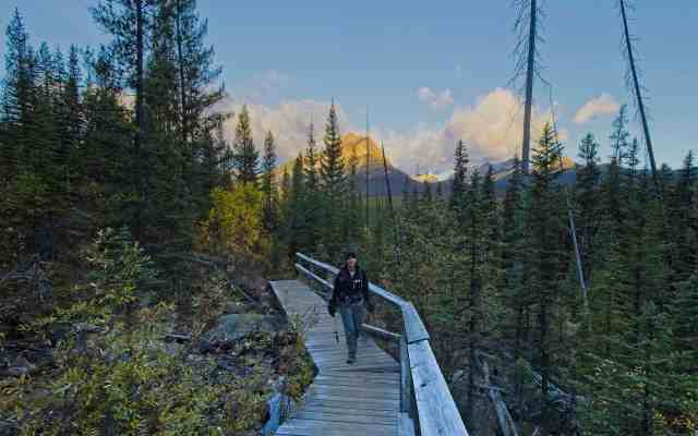
Lower Twin Lake sits just 750 meters beyond Upper Twin Lake. The trail descended another 50 meters or so and then emerged from the woods towards a double wooden beam “bridge” across the outlet of Lower Twin Lake. Lots of rocks, reflections and cotton grass added to the interest here.

Lower Twin Lake
Following the advice in our guidebook, we trod the boot beaten path along the east shore of Lower Twin Lake. Sections were very muddy. We gave thanks to those hikers before us who took time to place rocks in the worst of the muddy bits so that we only sank up to our toe caps!!
The waterfall on the far side of the lake was well worth the mucky detour.


We continued along the shoreline trail to the head of the lake (a little over 1 km from the double beam “bridge”). The view was fantastic! Here’s Mr. GeoK taking a multi-frame panorama shot…

…and here’s his final image.

Lower Twin Lake to Gibbon Pass
Leaving Lower Twin Lake, we followed the advice in our guidebook. Rather than retrace 1 km along the shoreline to rejoin the main trail, we headed up the drainage. And we did our best to follow the faint trail here. That worked pretty well for about 500 meters!

Then the faint trail became no trail! What to do? Revive our sleeping GPS unit and do our best to make it to the main trail, which seemed to be “50 meters that way” forever!! Finally, after about 800 meters of aiming for the main trail, we found it! At times the grade was > 50%. Not doing that again!
The really funny thing is that less than a week later I was having a front porch chat with a neighbour. And guess what!? She and her husband followed the same advice a couple of days later. And they also said never again!
The main trail was where we found all the golden larches on the blog post that made us decide on this hike.

Yes, they were a little past prime. But there are so many larch trees here that even with half the needles dropped, it was great.

Roughly 2.5 km and 250 meters elevation gain from the head of Lower Twin Lake (via the not recommended bushwhacking route), we spotted the Gibbon Pass plaque.

Gibbon Pass
A cool wind had us searching for a sheltered spot for lunch. Some 200 meters past the plaque we turned on to Little Copper Trail and settled in beside a group of “hippies on a stick” on the leeward side of a stand of sturdy spruce trees.

Eating lunch came second to shooting a time lapse and taking more photographs. The Ball Range was visible further to the southwest.

We seriously considered extending our hike. There are a few trail options for Little Copper: up and back from Gibbon Pass, short loop, long loop. In the end, we decided no. Why? Mainly because it would mean hiking at least part of the way back in the dark. Besides, it’s always good to have a new objective for a possible return trip. Studying maps back at home, a bike and hike via Redearth Creek looks like a good option. Or, post-pandemic, a stay at Shadow Lake Lodge.

Return
We started back just a few minutes before 2 o’clock. And we stuck to the main trail all the way back to the parking lot!

Two hikers were on their way up to Gibbon Pass as we approached Lower Twin Lake. Another couple skirted around us while we were taking a rest break at the double beam “bridge”.

Another couple of hikers passed us while we were checking out the tent pad sites at Upper Twin Lake. We overtook them at the saddle between Upper Twin Lake and Arnica Lake. They stopped at the saddle to check for a cell phone signal. I guess they got lucky, because they didn’t catch up to us even when we stopped for a few more photos at Arnica Lake.

From Arnica Lake back to the parking lot was a bit of a slog. At several spots, breaks between the trees provided a glimpse of the parking lot. For the longest time we didn’t seem to be getting any closer.

We encountered another half dozen+ outbound hikers between Arnica Lake and the parking lot. Surprisingly, one couple was leaving the parking lot as we finally got back about 5:30. Seemed a bit late of start for September 29, but they only planned to go to Vista Lake, so probably okay.
SUMMARY:
Four things put the day in the win column: 1) lots of golden larches; 2) four mountain lakes; 3) not many people; and 4) we identified another hiking objective (Little Copper). The only real negative was the off-trail misadventure recommended by our guidebook. We’ll think twice about following “line of sight” advice next time!
Distance = 23 km
Elevation gain = 1372 meters (713 net)
Hiking time = 7 hours plus 3 hours for lunch, photography/videography and rest stops (total 10 hrs)
Pingback: Nearby Nature Project: 2022 November/December - Out & About with the GeoKs
Nice job to describe the hike. We did it four days before you, and reached half way to Little Copper, with lots of clouds, no need to go to the summit if could not see Moint Temple, even could not see Mount Ball. Took us nine hours, one of the best larch hike in Banff. I would reach Little Copper next time, and visit the beautiful Shadow Lake. Great job you have done. We got down to Lower Twin Lake from Gibbon Pass, difficult to do, but I liked the adventure.
Thanks for the trip advice for next time. This one is definitely worth a repeat.
Pingback: Boom Lake - Out & About with the GeoKs
You found some real gems! Being outside is probably the ONE best activity to do during this pandemic to keep some sense of sanity. You are very fortunate to have such beautiful areas to retreat to during this time. I feel very sorry for those stuck in cities with no way to enjoy the fresh air and clear their minds. Hope you are having a wonderful Autumn. xoxo