
Heading into the second full winter of our COVID-19 discontent we continue to seek out winter hiking opportunities. And lacking AST1 avalanche safety training, we continue to screen winter hiking trails carefully. We limit ourselves to hiking trails that cover simple avalanche terrain (i.e. low risk, below treeline, few to no avalanche chutes, etc). Parks Canada’s winter trail recommendations and Alberta Parks’ snowshoe and cross-country ski trail are essential resources. We check Avalanche Canada’s latest bulletin. And we follow our usual safety routines – pack emergency and first aid supplies, let someone know where we’re going, when we expect to be back, and carry a GPS receiver with satellite messaging capabilities.
One area with low- to no-avalanche risk area is the trail network at Bow Valley Campground. Yes, the actual campsites and facilities close after Thanksgiving Weekend. But area trails are still accessible and offer opportunities for winter hiking, snowshoeing, cross-country skiing (not track set), geocaching, birdwatching and photography.
Another winter hiking option in this area is Yamnuska Natural Area.
Getting There
Travel Highway 1. Between the Kananaskis turn-off (Highway 40) and Lac des Arcs, take the 1X exit and head north. After than, turn into the Bow Valley Campground at the old-school sign on the west side of 1x. NOTE – as of June 2021, parking in this area requires a Kananaskis Conservation Pass.

When the campground is closed, you have two parking options. The first is at the (permanently closed?) Visitor Information Centre. Choose this lot for the 1.8 km Montane Trail loop or the 4.3 km paved trail that might work for cross-country skiing after a heavy snowfall. We have no experience on these trails during winter months. This lot may be the only viable parking option after a heavy snowfall event.
We’ve always continued along the paved road as it twists and turns, to park in the tiny lot at Middle Lake. There’s room for just a handful of vehicles here. If you see the locked gate, you’ll know you’ve gone to far.
Amenities include a pit toilet, as well as a few picnic tables near the small parking lot.

Middle Lake Trail
Drop down from the parking lot to the shoreline of Middle Lake via a short stretch of trail. If you’re interested in geology, stop at the information sign part way down the hill. The official Middle Lake Trail is a 2.5 km loop part way along the lakeshore and then through grassland and montane forest habitats. For information about theses habitats and the birds and animals that call this area home, bring along a copy of this Alberta Parks brochure about the Middle Lake interpretive trail.
Depending on how much distance you want to cover, you could hike the Middle Lake loop as your warm-up, cool-down or skip it altogether. In three visits, we did the full loop just once, with the interpretive trail brochure at hand to make it informative. And to find the geocaches hidden here.


Moraine Trail
Setting out from the tiny Middle Lake parking lot, there are two options to start a longer loop. Regardless, walk along the paved road and watch for the signed trail off the north (right hand) side. A very short distance along this trail is a t-junction. Continue north along the Moraine Trail or turn left (west) along the Elk Flats Trail.
We’ve always continued along the Moraine Trail, as it’s the shortest/fastest route to the Bow River Trail and we always try to time our arrival at the Bow River for sunrise (or at least golden hour).

Moraine Trail is a 1.6 km connector from the paved road to Bow River Trail. Interpretive signs and benches encourage a brief stop to study the growth pattern of the coniferous trees. Strong, prevailing westerly winds result in stubby branches on the west side of trunks and longer branches on the downwind side!

Bow River Trail
The Bow River Trail runs for about 1.5 km from the Moraine Trail t-junction, upstream to the Whitefish Day Use area (not accessible by vehicle during off-season). There are good views of Yamnuska and Door Jamb Mountain. And the scars of limestone quarries.


If you take any of the many boot beaten cuts down to the Bow River shoreline, you may even see parts of Graymont’s limestone plant/kiln.
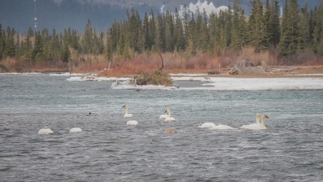
In addition to sunrise and golden hour mountain photography, we come to the Bow River Trail for the ice formations and the birds!


Over the winter of 2020/21, trumpeter swans and ducks hung out on this relatively flat and slow moving stretch of the Bow River.


Fall 2021 we spotted Canada Geese, ducks and scoters. We look forward to a return visit in November/December to see whether some swans are in residence.


One other feature we noticed fall 2021 is a human-made rock feature in the river. It’ll be interesting to see whether it survives the winter. Sad to think about the shoreline habitat destruction and interesting to consider what critters will appreciate this little human-made protected area.


Whitefish Trail
This “trail” is a short connector (400 m) to the Many Springs Trail parking lot. It regains a little bit of elevation, through mixed forest. Look for signs at the Whitefish Day Use Area parking lot, where you can also read about Mount Yamnuska.

A chattering squirrel came out to visit on our fall 2021 walk along the Whitefish Trail.


Many Springs Trail
If you’re short on time or energy, save the Many Springs Trail side trip (1.9 km loop) for another day.

But if you have the time and energy, adding the Many Springs Trail to our outing is well worth it. We’ve seen lots of birders hanging out near the bridge a long this trail, or along the boardwalk further on.


The many springs that feed the lake put on bubble shows that are best viewed from the second boardwalk. This is also a great spot to enjoy a wide open view of Yamnuska.
According to Gillean Daffern’s Kananaskis Country Trail Guide Volume 3, Many Springs Trail is also a good for spotting orchids and beavers. We’ve not visited during wildflower season, but we can state that the fall colours along this trail are quite impressive.

Elk Flats Trail
From the Many Springs Trail parking lot, look for the Elk Flats Trail just across from the outhouse. This 1.9 km trail connects back up with Moraine Trail via a somewhat undulating route through mixed forest. Poplars and aspens provide splashes of fall colour. Blue-purple juniper berries add interest down low. Watch for peak-a-boo views of McConnel Ridge, Pigeon Mountain and Mt. McGillvray.

SUMMARY:
Five trails mean you can tailor the hiking distance to suit the weather conditions and the capabilities of your group.
Moraine/Bow River/Whitefish/Elk Flats loop = 5.5 km loop with 30 meters net elevation change (100 meters total elevation change).
Add Many Springs trail to the loop = 8.1 km total distance with 30 meters net elevation change (140 meters total elevation change).
Middle Lake loop adds another 2.2 km and 60 meters total elevation change.
Final Thoughts
Bring more layers than you think you’ll need. Strong winds whip through this part of the Bow Valley and we were seriously chilled after our first hike along these trail. A hot drink to enjoy while bird watching would also be a nice treat. And if you tuck a pair of hand warmers into your pack, you can break them out in case of a chilled fingers!
We haven’t been here after a heavy snowfall, so don’t know how timely the road clearing is.
As always, proper trip planning and emergency preparedness will let you hit the trails with the peace of mind that comes from knowing you’ve done your best to create conditions for an awesome day in the great outdoors!
Pingback: Yamnuska Scramble and West Col Descent - Out & About with the GeoKs