
With our first successful completion of the Lake O’Hara alpine circuit almost four years in the past, we planned to replicate the thrill of completing the 11.7 km loop during this year’s visit to the Lake O’Hara region of Yoho National Park.
In the week before our trip, I was unable to find current trail condition reports for the Lake O’Hara region on Parks Canada’s website. When I called the front desk at Lake O’Hara Lodge, I was told the trails were clear of snow and hiking the full alpine circuit should be just fine. Turns out the person I spoke to wasn’t fully informed, because when we arrived at Lake O’Hara about a week later, we were advised against doing the full circuit due to the high incidence of rock falling onto the All Souls’ Alpine Route (typical and due to the daily freeze/melt cycle at this time of year). Not having packed helmets, we heeded the warning and settled for hiking 3/4 of the Alpine Circuit on the final day of our 2018 stay.
Except for the lack of blue sky, the weather was good. The cool temperature meant we could move at a pretty good clip up Wiwaxy. We had a few sunny breaks, no falling snow and just a few rain showers. Overall, the trails were somewhat wet with a few slippery sections on account of the previous day’s snow.
We’ve read that most people do the circuit in clockwise direction, beginning from Le Relais Day Shelter and striding along the Lake O’Hara shoreline trail to where the Wiwaxy Gap trail heads sharply uphill to the left. We’ve also traveled in the clockwise direction. I’m not sure I’d want to come down the Wiwaxy Gap Alpine Route – ascending the steps and ledges is daunting enough to someone with a touch of acrophobia. Coming down that trail doesn’t bear thinking about. 🙁
Wiwaxy Gap
Gaining almost 500 meters over 1.5 km, the Wiwaxy Gap trail is definitely a grind. With the temperature in the low double digits (Celsius), we hiked in short sleeves and light pants and were very comfortable. The cooler temperature allowed for a quick pace and we reached Wiwaxy Gap in about 90 minutes, despite several photo stops including one where we set up the tripod with a delayed shutter speed for a couple selfie overlooking Lake O’Hara.
Many of the photos that follow were selected because they show what the trail is like along the way, others because they show off some of the amazing scenery of the Lake O’Hara region.


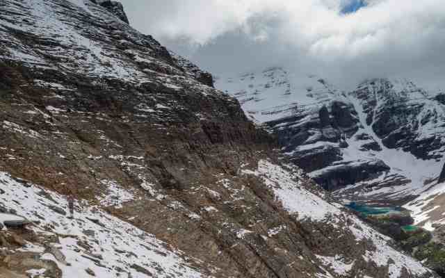
Huber Ledges
The Huber Ledges section of the Lake O’Hara Alpine Circuit is pretty straightforward. The net of the gentle ups and downs is that you actually lose almost half the elevation gained on the hike up to Wiwaxy Gap! This stretch offers some outstanding views of Lake O’Hara down below, so photo stops accounted for 30 of the 75 minutes it took us to reach the rock slabs that make up the western shoreline of Lake Oesa.


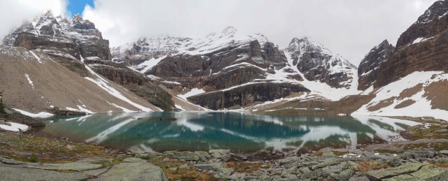

We ate lunch on the same rock we’d used as a picnic bench the previous day and Mr GeoK chatted with a couple of hikers equipped with helmets, who were heading up to the Abbot Pass hut after they finished lunch.
Yukness Ledges
After a half hour lunch break, we resumed our 3/4 Alpine Circuit by heading out along the Yukness Ledges trail. This is the one that woke me up in the night after we hiked it with our boys (then aged 9 and 13) back in 2008. I was pleasantly surprised to find that only a couple of very short sections caused me any anxiety this time out, and one of those was because it was snow-covered with a steep drop off that would have meant at least some bad bruises if I’d slipped.
Like Huber Ledges, there are some great viewpoints along this trail, so we kept our cameras handy and stopped often. Also similar to Huber Ledges, the (not always gentle) ups and downs net out to another modest elevation change – this time a net gain of about 50 meters over 2.2 km. Our time for this leg was 75 minutes, including 25 minutes for photo stops.


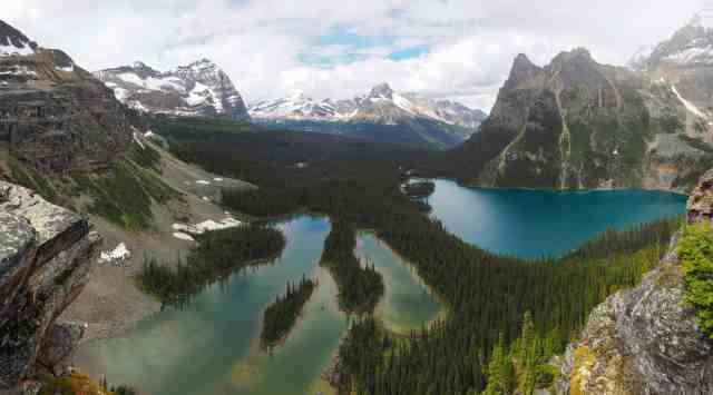
East/West Opabin
On reaching Opabin Plateau, we crossed the plateau using the trail between Hungabee Lake and Moor Lakes to the southeast end of the Opabin Highline Trail. Had we been continuing on All Souls’ Prospect for the final leg of the Alpine Circuit, we’d have made our way to the All Souls’ trail junction, which we explored for a short distance on the second day of our trip.
But since we’d already decided to heed advice against traveling All Souls’ Alpine Route where it hugs Mount Schaffer, we explored the Opabin Plateau trails a little more fully before heading back to the lodge in time for afternoon tea and our shuttle bus back to civilization.


Summary
Distance = 11.2 km
Elevation gain = 768 meters (571 net)
Time = 6 hrs 15 min, including 2 hrs 15 min for lunch and photography stops
Many consider the Alpine Circuit as the hike to do if you have only one day to hike at Lake O’Hara. We agree, so long as weather, trail conditions and what you’re capable of line up. What do you think? Is the Lake O’Hara Alpine Circuit on your list of “must do” hikes in the Canadian Rockies?
Pingback: Hiking Yoho National Park - Hamilton Lake - Out & About with the GeoKs
Pingback: Out & About with the GeoKs - Hiking Yoho NP – Lake O’Hara Golden Larch
Pingback: Out & About with the GeoKs - Hiking Yoho NP – Lake O’Hara Golden Larch
Pingback: Out & About with the GeoKs - Hiking Banff National Park – Beyond Rockbound Lake
Pingback: Out & About with the GeoKs - Photo Blogging Challenge – Get Out and Play (June 2019)
Such a beautiful area. That lake looks amazing, stunning photos!