
Grizzly Peak is one of our favourite hikes in the Highwood Pass area of Kananaskis Country. Access is limited by the annual highway closure from December 1 through June 14. But from June 15 until the snow depth is beyond your comfort zone, hiking through Pocaterra Cirque to Grizzly Col to Grizzly Ridge to Grizzly Peak is a great option for a half-day hike.
For Canada 150 larch madness, we wanted no avoid the Banff National Park trails that are most popular with gold seekers (although we’d have made an exception for Lake O’Hara trails if we’d been lucky enough to book seats on the bus when sales opened for about 10 seconds last spring).
By opting for Grizzly Peak, we enjoyed a relatively quiet trail experience once we got past the trail fork in the meadow of Pocaterra Cirque.
Getting There
Parking is in the Highwood Meadows parking lot, just past the Highway 40 summit, about 45 minutes south of the TransCanada highway. This day use area is also trailhead parking for Ptarmigan Cirque and the Highwood Meadows Boardwalk (closed for construction from mid-September through early October 2017). Amenities include a couple of pit toilets, some benches and a bearproof garbage can.
When we arrived just before 9 am on a late September Saturday morning, there were about a dozen vehicles in the parking lot. When we pulled out around 2:30 in the afternoon, the parking lot was jammed and more vehicles were parked along the highway.
Gentle Warm Up
The flat stretch of wide gravel path, starting from the north end of the parking lot to where there’s a sign on the left that says something about a sensitive area, is just long enough to serve as a gentle warm up. Turn left into the meadow here! Over the many years we’ve hiked in this area, the single path across the long meadow has become a shallow trench and boots have established a parallel path to the edge woods.
First Ascent Stage
Patches of recent snow made the gentle climb through the woods more challenging than usual. In addition to navigating the mud of the perpetually boggy sections, patchy snow made even slight inclines and declines treacherously slippery. We saw plenty of skid marks left by those who made an early start. After a couple of close calls ourselves, we stepped off the trail and dug our MICROspikes out of our packs, which made the going much easier.
Emerging from the woods to the edge of the talus slope below Highwood Ridge we caught our first glimpse of snow-dusted larch!

By the time we reached the tarn with its skiff of early morning ice, we’d said “Hello” to four other pairs of hikers. We kept leapfrogging one another thanks to the many photo stops to choose from along this stretch.
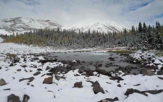
After a short detour to check on one of our geocache hides, we continued towards Pocaterra Cirque, pausing a couple of times to look back and enjoy the scenery.

Second Ascent Stage
At the cairn in the meadow just below Pocaterra Cirque, we turned left towards Grizzly Col. Mr. GeoK was in the lead and he followed a solo hiker’s set of up and back boot prints in the snow. The skid marks we’d seen in the forest must have belonged to hikers eager to reach the high point of Pocaterra Ridge, as there were no signs of them here.
The snow was deeper here, so we paused near the base of Mount Tyrwhitt to don gaiters.
As we worked our way up and across the steep slope below Highwood Ridge, clouds rolled in and the wind picked up, dimming the sun that was just higher than the ridgeline.

Accumulated snow made it easier than usual to get around the rocky crux that’s the toughest bit between Pocaterra Cirque and Grizzly Col. With another half-dozen hikers behind us, we worked to improve the track through the snow as we continued to follow in the boot prints of the previous day’s lone hiker.

We reached Grizzly Col in under two hours. A chill wind continued to blow, but clouds cleared out for a bit while we enjoyed the views in both directions. We knew we’d made the right choice of trail for us when we saw the almost continuous line of hikers making their way up to the high point on the Pocaterra Ridge trail.


Third Ascent Stage
During our snack and photo break, six more hikers joined us at the Col. Two had plans to scramble up Mount Tyrwhitt. While the others broke out extra layers and snacks, we opted to head up to Grizzly Ridge for a look down into Paradise Valley and across to Ptarmigan Cirque and Mount Rae.
The previous day’s solo hiker had not ascended to Grizzly Ridge. Instead, we saw the same boot prints descend the other side of Grizzly Col and break trail well along the valley between Grizzly Ridge and Storelk Mountain.
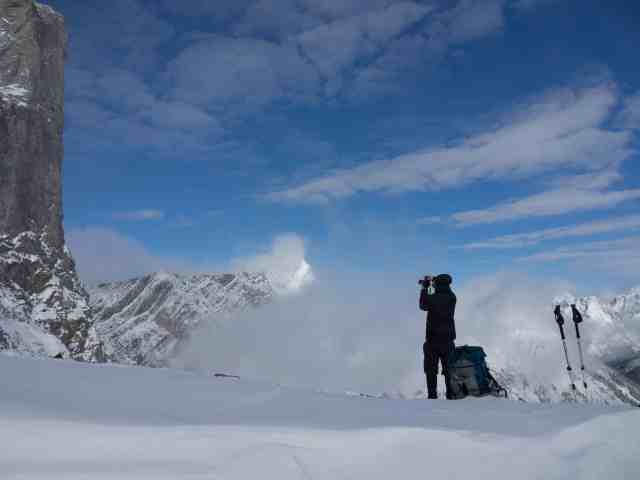
As we resumed hiking, the snow was even deeper, with some drifts thigh high. We took turns route-finding and breaking trail, thankful for our gaiters, spikes and poles. Cresting Grizzly Ridge, the views into Paradise Valley were definitely worth the extra effort.

After composing a few panorama shots, we hunkered down on the leeward side of Grizzly Ridge for lunch. More clouds rolled through as we ate, and by the time we’d stowed the remains of our meal in our packs, Mount Rae and Ptarmigan Cirque were mostly hidden.
We remained hopeful there’d be a break in the clouds and hung about for a while, moving along the ridge to Grizzly Peak, taking some photos, providing directions to one guy who thought he was on Pocaterra Ridge and answering questions about how easy it is to traverse Highwood Ridge and then descend to the parking lot (not) posed by two other couples. It was fairly disconcerting that so many hikers were out there without seeming to have researched their route.


Return
 The clouds never did clear enough to give an unobstructed view of Mount Rae before we made the decision to start back down. We encountered another dozen or so hikers before we reached Pocaterra Cirque, but that was a tiny number compared to the more than 50 we counted (thanks to a telephoto lens) nearing the high point on Pocaterra Ridge!

Below the Cirque, the trail was a little muddier and a lot more crowded than it had been when we were hiking the other direction. We definitely weren’t the only ones looking to enjoy the short-lived golden larch season in the Canadian Rocky Mountains!


Summary
Total distance = 10 km
Total elevation gain = 665 meters (537 net)
Total time = 5.5 hours, including 2 hrs 15 minutes for lunch, photography and waiting for the clouds to clear
This is a good option any time during the short hiking season in the Canadian Rockies, especially during wildflower or larch season. Depending on the month, this can also be a good area to spot Rocky Mountain Bighorn Sheep.
Other larch season hikes in this area include Ptarmigan Cirque, Arethusa Cirque and Pocaterra Ridge. Which trail is your favourite during larch madness?
Pingback: Photo Blogging Challenge – Colourful (September 2018) | Out and About with the GeoKs
Wow! Stunning pictures Mrs. GeoK! When I looked at that hike from Pocaterra Cirque and Pocaterra Ridge last year, it looked scary steep. Are there any spots where some one who does not like exposure would get stressed? I would love to give this one a go.
There is one very short section (2 – 3 meters) where I was pretty stressed the first time I did it. Over the years, the stress has pretty much disappeared. The key for me at the little rocky outcrop is to give someone else my poles and hold on directly to the rocks. After 2 or 3 steps, you’re over and around and done! The Col is not a problem, nor is Grizzly Ridge heading west. I haven’t ventured very far along Highwood Ridge as it drops off too steeply on both sides for my peace of mind. For me, the 30 seconds at the little outcrop is a small price for the amazing views into the valley on the other side of Grizzly Col.
Thank you! Good to know. It was those 2 or 3 steps on EEOR that gave me such a hard time. I will have to think about this. Happy Thanksgiving and happy trails to the GeoKs!