
When the top of the calendar page says September, it’s time to prepare for golden larch season in the Canadian Rockies! This includes selecting one or more hiking trails, possibly booking a day off work or making other schedule changes to allow for a mid-week hike, adding warmer layers/gaiters/foul weather kit to the hiking pack and conditioning. After all, the objective is to enjoy the scenery without getting chilled or suffering sore feet or tired legs.
After trying several years in a row, we finally managed to book seats on the Parks Canada bus to Lake O’Hara. Even better, our reservation is for mid-September! Determined to make the most of our opportunity to photograph golden larches on the Opabin Plateau, we are especially focused on conditioning this year. Following the short, steep guided hike to the Mount Stephen trilobite beds, we wanted similar elevation gain and more distance for our second conditioning trail.
We last hiked to Rockbound Lake in October 2014, well after peak larch season. It ticked the boxes for elevation gain and distance. Three other things sealed the deal: 1) it’s not popular, so wouldn’t be too busy; 2) there are larches; and 3) the option to hike beyond Rockbound Lake – to the hanging cirque, to Helena Ridge, or even to the Bow Valley overlook near Eisenhower Peak.

Getting There
We opted to drive the TransCanada highway from Canmore to Castle Junction. Highway 1A is another option. The Rockbound Lake trailhead is clearly signed, about 200 meters to the right of where you turn onto the Bow Valley Parkway (Highway 1A) towards Banff. There was just one other vehicle in the parking lot when we arrived a few minutes after 8 o’clock.

Trail to Rockbound Lake
After five years, we’d almost forgotten that the front section of the trail is quite boring. A few touches of fall colour and a wide variety of mushrooms added some interest and a short stretch of boardwalk that breaks the monotony. Otherwise, it’s a gentle ascent along an old road, wide enough to allow for easy conversation.


We also kept an eye on the buffalo berry bushes. They were picked clean for the first 4.5 km, and then we saw the occasional bush with a few dozen berries. The scarcity of berries and the absence of any large mammal scat made us fairly confident there were no bears feeding in the area. But just to be sure, we stuck with our usual rhythm of “Hey-o” and “Yo, bear!”
About 5.5 km along, the trail narrowed, flattened out and turned into the mouth of the hanging,round valley between the back of Castle Mountain and Helena Ridge. There were a couple of muddy sections where some work has been done to install double wooden beams and flat rocks to get through the worst of it. The other big surprise was the number of wildflowers still in bloom: heart-leaved Arnica, pink flea bane and scarlet paintbrush. And soon, Helena Ridge and Eisenhower Tower come into view…

The geology of Castle Mountain is quite unlike . We found the geology quite unlike the mountains we usually hike in Banff National Park and Kananaskis Country. This is because Castle Mountain is in the Main Ranges of the Canadian Rockies, whereas our more usual hiking area is in the Front Ranges. The primary difference is that the various layers of rock in the Main Ranges are mostly still laying flat, which means as soft supporting layers erode the harder layers above eventually succumb to gravity and break off, forming a mountain with fairly vertical walls. In contrast, the rock layers in the Front Ranges are quite steeply tilted, so they erode away in sheets, forming more angled mountainsides. The other difference that’s easily observed is in terms of colour, with the Main Ranges being more colourful (purple, green, pink, etc.) than the mostly grey rocks of the Front Ranges.
At 8.5 km, having gained 720 meters, we opted for a photography stop at Tower Lake. Except for the occasional surfacing fish, the water was absolutely still.


The 0.5 mile distance indicated on an old sign at the head of Tower Lake was misleading. It was another 1.3 km/110 meters elevation gain to our lunch spot at Rockbound Lake.

Despite the flat cloud cover, it was very comfortable – somewhere in the mid-teens C temperature-wise. And with no wind, Mr GeoK was comfortable in shorts and a t-shirt as we settled in for a slightly early lunch around 11:30.

Beyond Rockbound Lake
Since it was just barely noon by the time we packed away the remains of our lunch, we decided to continue up to the first bench overlooking Rockbound Lake – about another 200 meters elevation gain in just 15 minutes!

It was during this short stretch that we met the couple who’d beat us to the parking lot.
As someone who’s had to work hard to overcome extreme discomfort around any sort of exposure, there were a couple of stretches here where the me of five years ago would have been unable to proceed.

I’m glad I was able to make it to the upper hanging valley. The views were fantastic! The deep blue colour of Rockbound Lake was much richer from the higher vantage point and the colour contrast between Tower and Rockbound Lakes was remarkable. We also spotted several marmots and enjoyed the sight and sound of a small stream flowing across the hanging cirque above the lake and below Helena Ridge.


Return
As we made our way across the upper bench to the steepest part of the trail, we met two other pairs of hikers. As with the couple we’d met earlier, all were visiting from Europe. Both groups were determined to continue to the overlook across the valley, reached by hiking along the upper ridge. The additional distance and elevation gain were beyond us today, so we wished them well.
Before heading down the steep section, Mr GeoK shot one more panorama.

And we posed for a delayed shutter-release couple selfie! It took two attempts before Mr GeoK made it in time to turn and face the camera. 🙂

As the route leveled off at the lakeshore, we spotted our first (and only) large mammal of the day: a lone Rocky Mountain bighorn sheep.

A few of the smaller larch trees near Rockbound Lake were just starting to turn colour, which bodes well for ten days from now at Lake O’Hara.

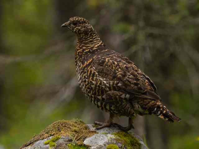
The trek back to the parking lot was pretty much a matter of putting one foot in front of the other and moving as quickly as possible! We encountered just four other hikers, bringing the total for the day to ten. And we spotted three spruce grouse(?), including this one that posed for Mr GeoK.
SUMMARY:
Total hiking distance = 21.6 km
Total elevation gain = 1050 meters (977 net)
Total hiking time = 8 hours 15 minutes (including 2 hours 15 minutes for lunch and photography)
Despite the boring front end, we would do this hike again, with an earlier start and the aim of hiking at least part of Helena Ridge. Another option to change things up is to add a side trip to Silverton Falls.
What’s your favourite fall hike? And what’s your best tip for staying safe and comfortable while hiking at this time of year. Links to blog posts or photos are welcome.
Pingback: Out & About with the GeoKs - Photo Blogging Challenge – Nature (September 2019)