
It looks like 2020 is going to be our year for long hikes. After one hike in late June and another in early July, it’s clear that Canadians are fully on board with our chief medical officers’ advice to get outside! Trails are busier than ever – even busier than 2017 when we all got free annual passes to Canada’s National Parks! And while it’s great to see so many people embracing #greentimenotscreentime, it makes physical distancing on trails pretty difficult. In previous years, we observed that only a small percentage of hikers are able and willing to tackle the longer the trails. Based on our first 20+ km hike of 2020, that seems to still hold true. We encountered about 30 people on the trail to Piper Pass (including one group of 11), vs about 50 on Wind Ridge (14 km, 897 meters total elevation gain) and several hundred on Ha Ling.
Now that we’ve hiked it, we’re not sure how we overlooked Piper Pass in our 20+ years of hiking in the Canadian Rockies. It met our three primary screening criteria for 2020: 1) longer than 20 km; 2) recent trail reports indicate it’s mostly snow free; and 3) two or more guidebooks / websites / blogs recommend the hike as worth doing. This post is what prompted us to research Piper Pass.
Getting There
There are two approaches to Piper Pass. The only approach workable for dayhikers is the one starting from the Elbow Lake/Elbow Pass Day Use area along Highway 40.
The other, much longer approach is by way of the Big Elbow Trail from Forget-me-not Pond off Highway 66 near Bragg Creek. Mountain bikes (and horses) are permitted on the Big Elbow Trail, so Piper Pass is a bike and hike candidate – although if the section of the Big Elbow Trail between Highway 40 and the Piper Pass Trail intersection is anything to go by, it’s beyond our mountain biking skills/aspirations! Piper Pass is also a dayhiking option for campers who manage to reserve a couple of nights at Tombstone Backcountry Campground.
Driving south on Highway 40 from the TransCanada, we spotted a black bear moving into the trees, a couple of Rocky Mountain Bighorn Sheep beside the road, and two white-tailed deer crossing the highway.


We pulled into the Elbow Pass Day Use area just before 7:30 on a weekday morning. The parking lot was about half full. Puddles of overnight rain on many of the vehicles indicated most of them belonged to overnight back-country campers.
The Trail
We didn’t need to worry about the cool 4C temperature for long. From the parking lot, the wide trail climbs 160 meters over the 1.6 km to Elbow Lake. Fortunately, birdsong, wildflowers and trying to spot the peeping pikas distracted us from the steep grade. After things leveled out a bit, we spotted a spruce grouse just off the trail.

We were early enough that we ended up hiking through steam! As the sun climbed higher in the sky, it evaporated the moisture left by overnight rain.

Elbow Lake
Novice hikers and families with younger children can make an enjoyable half day of the 4.2 km / 195 meter gain hike up to and around Elbow Lake. If the campground isn’t full, you might even find a picnic table for lunch. If not, there are plenty of fallen trees and rocks along the shoreline.
We reached Elbow Lake Backcountry Campground in half an hour. Although the position of the sun was problematic for photography, we took several minutes to take pictures and shoot a bit of video. One of the campers chatted with us from a safe distance, commenting that although all sites were reserved, about 40% were empty overnight.

Circling around the west shoreline of Elbow Lake, we were overtaken by two guys on mountain bikes, their packs stuffed with climbing gear. I spent the next few minutes wondering whether it isn’t better to wear a climbing helmet than to go with no helmet while mountain biking. Anyone?
Approaching the small wooden bridge over the outlet of Elbow Lake (the start of the Elbow River, which joins the Bow River at Fort Calgary), we saw some people fishing and a few more campers along the far shoreline.

Elbow Lake to Edworthy Falls
From Elbow Lake, Big Elbow Trail roughly follows the nascent Elbow River, heading pretty much due north. It’s wide – physical distancing is not a problem, so long as everyone’s hiking single file. There are a couple of pinch points where creeklets cross the trail at an angle and there’s only one set of stepping stones.

The valley is wide here. Wildflowers bloomed in abundance, including windflowers, showy locoweed, wild vetch, silky scorpionweed, scarlet paintbrush, pink moss campion, twinflowers, wild strawberries, willow, heather, buttercups and faded white western anemones.

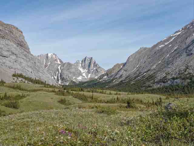
Had we pulled out our topo map when we spotted the somewhat symmetrical jagged peak across the expansive meadow, we’d have realized we were looking at the aptly named “Cats Ears” and that our objective for the day was just off its right shoulder.
Also along this stretch we spotted the first (of many) patch of lingering snow.

Edworthy Falls
We were on the lookout for a rock cairn about 3 km (45 minutes to an hour) from the bridge across the Elbow River. On the left (west) side of the trail, it marks the start of the short trail that overlooks Edworthy Falls.
There’s a fair bit of trail braiding here, and we also saw the messy evidence of a random backcountry campsite. Look for flagging and stick to the widest, most established trail to find Edworthy Falls.
It’s a bit of a slippery scramble down to the rounded spit of land that’s level with the base of the falls.

Edworthy Falls is a worthy destination for dayhikers, clocking in at about 10 km (return) and around 200 meters elevation gain.
Edworthy Falls to Piper Pass Trail
The turn off onto Piper Pass Trail is just 450 meters (5 minutes) from the Edworthy Falls cairn, and is marked by a second rock cairn and a piece of flagging. We spotted a group of 11 hikers stopped on the trail ahead of us a couple of minutes after leaving Edworthy Falls and, sure enough, they were headed to Piper Pass.
Piper Pass Trail
The Piper Pass Trail is a narrow track that starts by dropping about 25 meters elevation over 250 meters through the woods. At this pinch point, hikers are confronted by the Elbow River, now wide enough that it can’t be jumped and deep enough that stepping stones aren’t adequate. Most of the 13 of us opted for boots off to ford the creek, but a few moved slightly upstream to the log “bridge” for the crossing.
No photos here, as we put on a burst of speed as soon as we crossed the river, regaining the 25 meters and a bit more as we climbed to a narrow meadow where we finally stopped to swap our sandals for our boots.

By the time we reached the rough and ready log crossing over Piper Creek (about 600 meters distance from the Elbow River ford), the group of eleven was several minutes back and we didn’t see them again until we were in the expansive meadow just below Piper Pass.
We were able to keep boots on to cross Piper Creek, but were grateful for our trekking poles, which we used to stay balanced on the slippery logs.

We were soon back in the forest, this time for two to three km. The shade would be a blessing on a hotter day.
We spotted thousands of glacier lilies along the forest trail – noteworthy because we usually see them on sunny, open slopes or the fringes of the forest.

Also spotted some gumdrop fungi and once the trail returned to roughly parallel Piper Creek (where it’s carved Piper Canyon), the forest thinned out on the downhill side and we saw shooting stars, pussytoes, wild vetch, scarlet paintbrush and more.

At one point, we realized we heard a new waterfall every time we turned a corner. Piper Creek has carved a deep canyon, so it’s hard to get line of sight on the falls.


We just about cleared the treeline when I spotted a bunch of random holes/caves along the eastern side of the Opal Range. My imagination had no trouble arranging one group of holes, cracks and protrusions into the face of a rock spirit. Do you see it?

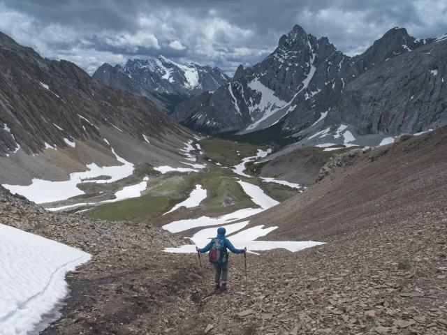
A few minutes later, things really opened up and we realized we were approaching an expansive alpine meadow. At this point we could also see the trail up the brown scree slope, to the notch in the ridge line directly above the trail in this photo – our turnaround point, Piper Pass.

In the meadow, the trail evaporated, or maybe disappeared under lingering patches of snow. Regardless, we knew our destination and continued hiking in that general direction. Plenty of Richardson ground squirrels scurried about, but none of the marmots we’re most accustomed to spotting in alpine meadows. We’d like to make a return visit some year, a little later in the season, to check out the upper reaches of Piper Creek Canyon.

A monolithic boulder marks the upper end of the meadow and is the logical place to make the go/no go for the pass decision. We opted for go! This photo makes it look like a breeze to get to the pass. In reality, I gained about 100 meters elevation over the last 250 meters distance, on screen and snow. It was on the final climb to the pass that one member of the group of eleven overtook me…I’d been stamping steps into the snow as I climbed, and need a rest break, so one of the group, close on my heels, took the lead and stamped steps into the final stretch of snow, thus beating me to the pass!

Mr. GeoK’s final approach was even more gruelling, as he opted to go high up on the brown ridge line and then back down to the pass.

Here’s the elevation graph from our GPS track:

Was it worth the effort? For sure! Look at these views…first to the north…

…then to the south.

As is usual at a mountain pass, the wind was howling. I put on every layer I’d packed (wool shirt, polar fleece, nano puff and rain shell) and was still cold. We started (but did not finish) our lunch, opting to head back down to the meadow to finish eating.
I carefully tightened my boots before starting down – hard to do when fingers are so cold!

And while I managed to stay upright all the way down, Mr. GeoK lost his footing on one of the snow patches and pulled ahead of me as he slid about 20 meters!
Down in the meadow, we found a sheltered spot near this tarn to finish our picnic.

As we ate, the group of eleven passed by on their way down. We relaxed a bit, eventually packing up to head back at about 2:30.
We took a few photos to show trail conditions as we hiked back.


And I spotted some late crocuses flowering, because on an out-and-back hike, it’s inevitable that you spot something on the way out that you missed on the way in. 🙂

Where did we overtake the group of eleven? Inevitably, it was at the worst pinch point on the entire route – the Elbow River ford. Mr. GeoK opted for the log crossing on the way back, while I donned my sandals to wade across. And I kept them on until we’d ascended to the junction with Big Elbow Trail where I made the fastest footwear change ever! We didn’t see the large group again.
But we did see several couples and family groups between the Piper Pass trail junction and the trailhead parking…maybe 40 to 50 people in total over the day, not all that surprising given the shorter options to hike the loop around Elbow Lake, hike to the meadows along Big Elbow Trail, hike to Edworthy Falls and even some backcountry campers heading to the Tombstone Backcountry Campground.

SUMMARY:
All in all, it was a very good day. We had great weather, the wildflowers were abundant and colourful and it made our “must do again someday” list!
Total hiking distance = 22.3 km
Total elevation gain = 978 meters (623 net)
Total hiking time = 9 hours 15 minutes (including 3 hours for lunch, snacks and photography)
Pingback: Experiences - Out & About with the GeoKs
Thank you for the detailed description of your journey! It makes us at ease to embark on this hike. I wish you happy hiking in 2021 and am looking forward to read about more of your great adventures. Jitka K
Hoping your hike to Piper Pass is as awesome as ours was. Happy trails!
I absolutely love your descriptions and photos. Your authentic voice and clear, accurate narratives, combined with the pictures and extra details, make your entries so enjoyable to read! I am sharing links to several of the hikes with friends who are staying in the Kananaskis in September. Thank you for sharing your enthusiasm for the outdoors!
Thanks so much, Susan. September is a wonderful time to enjoy Kananaskis – crisp mornings, fall colour and maybe a picturesque dusting of snow on the mountain peaks.