
Floe Lake and Numa Pass are part of the multi-day backpacking route between Marble Canyon and Vermillion Crossing in Kootenay National Park: the Rockwall. Most itineraries describe it as a four to five day adventure, and recommend starting with the trail into Floe Lake. Since we’re strictly day hikers, we ascended the trail to Floe Lake for lunch, continued to Numa Pass in the early afternoon and retraced our route arriving back at the parking lot a little before 6 pm. A long and rewarding day, the Floe Lake backcountry campground has got us thinking about giving backpacking a try.
Getting There
Our driving time from Canmore was approximately one hour, starting on the TransCanada Highway and then turning onto Highway 93 at Castle Junction. Castle Mountain was draped in cloud lit up by the early morning sun.

The Floe Lake trail parking lot is just off Highway 93 in Kootenay National Park, between Marble Canyon and Vermillion River Crossing. When we pulled in at about 7:30 on a weekday morning, we noted about 30 vehicles in the parking lot, all but 3 with Alberta license plates.
The Trail
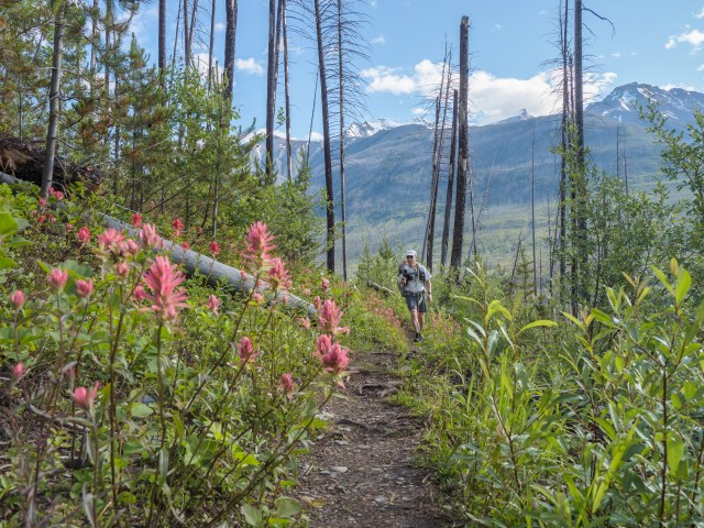
The trail starts flat for a few minutes before losing a bit of elevation in the approach to a bridge over Vermillion River. The first 5 km or so traverse an area marked “2003 burned area” on the topo map we carried. Some 18,000 hectares burned in one of BC’s worst wildfire seasons, and the vegetation is a mix of mostly standing dead/burned trees, a few mature trees that miraculously escaped the fire, plenty of “baby” trees and shrubs and abundant wildflowers.
Photography at the bridge over Vermillion River was near impossible with the sun just rising over Hawk Ridge across the valley. Light was much better in the late afternoon, as we returned to the parking lot, when this photo was taken.

Once across the bridge, we regained the bit of elevation loss and then enjoyed about 2 km of mostly flat walking in new growth forest, with trees between 2 and 5 meters in height. There were tons of wildflowers, lots of fungi on the fallen, burned old forest remains and we heard birdsong all around. It would be easy to get bogged down on this stretch, taking all kinds of photographs, but we knew we were in for a long day and kept up a reasonable pace to the second bridge, which crosses Floe Creek.

From the second bridge, the trail climbs for a bit, gaining maybe 100 meters elevation over a km or so. Then things generally level out, traversing the sloping north side of the valley carved by Floe Creek. There’s a wide open view to the south side of the valley, where standing, burned trees and what we presumed to be avalanche chutes paint a silver and green diagonal stripe on the slope.

It’s also about here that I noticed clump after clump of pink paintbrush flowers. They were in full bloom in mid-July. By the end of July, the budding fireweed should be in full flower.
The wide open views across the valley are due to the 2003 wildfire. Almost two decades on, there’s evidence of the extensive burn everywhere we looked, including the fallen trees cut and moved just enough to create a gap for the single-track trail…

…. charred stumps and standing dead trees.

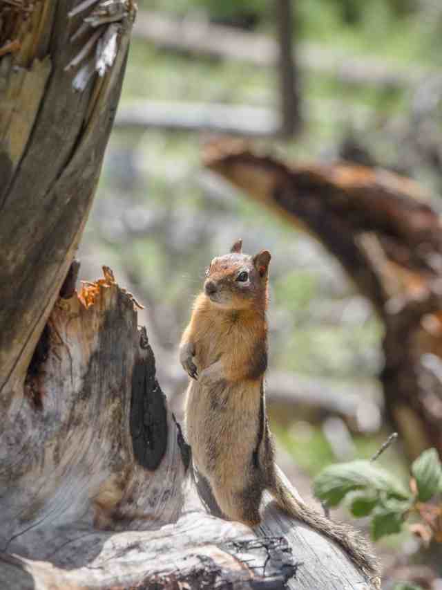
We also saw two of the small mammals most frequently spotted in Kootenay National Park: a hoary marmot…

…and multiple, curious golden-mantled ground squirrels including this one who stood up the better to check us out!
Six km from the parking lot, the trail makes a sharp turn to the right and gains a wee bit of elevation. This is a good spot to pause and look back along the Floe Creek valley and really study how the wildfire affected (and is still affecting) the land.

Roughly 2.5 hours (7 km) from the parking lot we came to a third bridge, this one less elaborate that the first two, and crossing a stream with no name, perhaps seasonal as it flows down the shoulder of Numa Mountain before joining Floe Creek.

From the bridge, the vegetation was overgrowing the trail.

Fortunately, the jungle thinned out after a hundred meters or so and we soon came to a spot that had a great view of Floe Creek flowing down from Floe Lake, which gave us a pretty good idea of how much elevation we had to gain to reach the lake itself.

Sure enough, about three hundred meters on we had to cross another tributary of Floe Creek. It looked to us like a winter of 2019-20 avalanche obliterated the previously well-established crossing, so it was fairly rough and ready for maybe 15 or 20 meters and then we were back on the boot-beaten track.

Then we were climbing through the forest, up multiple switchbacks. This is the toughest part of the trail to Floe Lake, gaining about 360 meters over 1.8 km.

Yes, a grind, made more challenging by three or four more missing sections of trail, like this one.

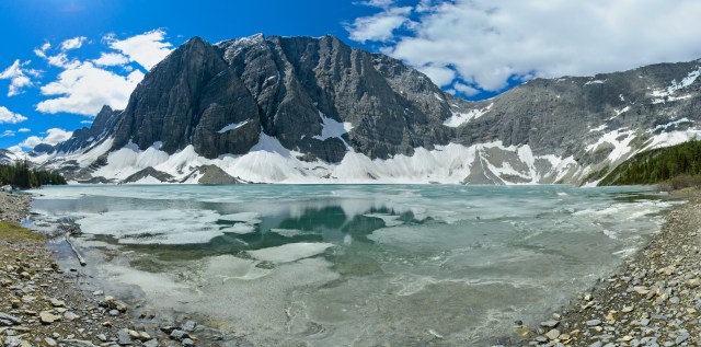
Then we spotted turquoise water through thinning trees and, after a short walk through terrain that reminded us of the Opabin Plateau at Lake O’Hara, we arrived at Floe Lake! It’s hard to imagine a more scenic picnic area than this one.

Even so, ice remnants on the lake drew us to a small cove along the shore as the site for our picnic lunch. Mr GeoK broke out his gimbal-mounted 2020 iPhone SE to shoot some timelapse video. I was enchanted by the way little bits of ice sounded like wind chimes as the waves pushed them towards the shore.
After lunch, Mr GeoK went into panorama shooting mode, an option well-suited for the dramatic scenery.

Meanwhile, he suggested I head over to check out the Warden’s cabin on the trail to Numa Pass. So, off I went, first to the cabin (unoccupied when we were there)…

…and then on to Numa Pass, along a trail with lots of snow patches and that crossed through extensive high alpine meadows.

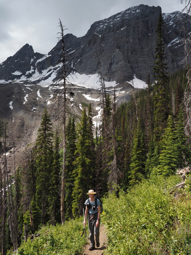
I stopped frequently to take photographs and to chat with backpackers coming from the Numa Creek backcountry campground, all the while wondering when Mr GeoK was going to overtake me. Eventually, I gave myself until 2 o’clock to reach the pass or turn around, knowing there was a long return hike to the parking lot ahead of us.
I reached Numa Pass at 1:50, and as I took off my pack for a bit of a break while taking photographs, I spotted Mr GeoK crossing the last big patch of snow below me, as he paused to take this photo of me at the pass.

When he joined me at the windy pass, he exclaimed that he’d never meant for us to hike all the way to Numa Pass, just that the warden’s cabin was in the same direction of the Numa Pass trail. I guess I heard what I wanted to hear! And this was a good reminder that we really should bring our walkie-talkies.
Anyhow, we stayed at the pass for 15 or 20 minutes, shooting panoramas in both directions.


At 2:20, we finally started back, reaching the parking lot at 5:45. Of note:
- On the descent from Floe Lake, we heard a couple of cracking sounds in the woods. I thought it might be a large animal, but Mr. GeoK spotted a hiker ahead of us and figured they were banging their hiking poles against a fallen tree or something. Nope! It turned out to be a tree that, after the second crack, fell over about 50 meters behind us, with a loud crash that sent up a cloud of dust and detritus! That made me a little uncomfortable for the rest of the downhike, especially where the trail goes through all those standing dead trees from the 2003 fire.
- We encountered at least a couple of dozen hikers between Floe Lake and the parking lot, including one group of 9 ladies at the rough and ready creek crossing. That brought our total number of other hikers seen over the entire day to somewhere around 45.
Here I am looking a little fatigued, just before Mr GeoK pulled a chocolate chip cookie he’d stashed in his pack out to share with me – a little pick-me-up for the final push to the parking lot. 🙂
SUMMARY:
Another fantastic, full-day hike – one that’s got us thinking about trying backcountry camping. 🙂 We’d rate this one as challenging, due to the total distance and elevation gain. Trekking poles are a must for this one!
Total hiking distance = 27.3 km
Total elevation gain = 1338 meters (1028 net)
Total hiking time = 10 hours 15 minutes (including 3 hours for lunch, snacks and photography)
I did this hike, just to Floe Lake, in 1977 when I was 20 years old. As I recall I did not find the switch backs all that tough. Thirty three years later, in 2010, I completed the hike with my 22 year old son. The switchbacks were a lot tougher this time around. The views in and out to Floe Lake were more spectacular than my first hike there because of the forest fire of 2003. I may get back to this hike once again but next time I am taking hiking poles!
Yep, we sure appreciated the hiking poles, especially on the way down. And yes, “maturity” has a way of making the trails steeper and longer. 😉
I had the unforgettable privilege of over-nighting in the warden’s cabin with my Parks Canada friend a few years ago!
If you need any back-packing gear, for your trial, Rent-A-Tent can fully outfit you.