
We finally made a long-overdue return to Yamnuska in early September 2022. We last did this scramble in 2007, before we started blogging. And that was waaaaay before Alberta Parks closed the area for six months in 2021 to make much needed upgrades, including a new descent trail.
Why so long? We consider the weather AND air quality forecasts when hiking. Who wants to drive two hours to the trailhead followed by several hours hiking to a summit or mountain pass, only to have limited views due to wildfire smoke? And what about the long-term lung health consequences of breathing all those particulates so deeply into your lungs as you huff and puff your way up?
So when it’s smoke season (can’t believe this is actually an annual “thing” for the past several years), we choose from shorter hikes that are closer to home. Then, if there’s a morning or afternoon when air quality is “in the green” we head out for some exercise and a dose of Vitamin N(ature). Throw in some decent views or a bit of a on-trail excitement and you’ve got a recipe for opportunistic hiking success!
Yamnuska’s been on our list of half-day Goldiocks destinations for a while now. In early September, after weeks of no rain, with a good weather forecast and decent air quality, we finally got out to experience the trail upgrades for ourselves.
For a video recap of our hike, click here. For all the details, read on…
What’s in a Name?
A bit of research surfaces three names for this mountain:
- Îyâ Mnathka – the original Stoney Nakoda name that describes steep cliffs or the “flat-faced mountain”
- Yamnuska – the English version of the Stoney Nakoda name, which translates to “wall of stone”
- Mount John Laurie – the official name assigned in 1961, at the request of the Stoney Nakoda nations, to recognized John Lee Laurie, a founder of the Indian Association of Alberta, an educator and political activist

Regardless of name, this mountain is geologically unique. It’s the result of the McConnell Thrust Fault. As a result, erosion-resistant Eldon Formation Cambrian carbonate rock is on top of the 450 million years younger Cretaceous Belly River Formation. The vertical south face has more than 150 climbing routes.
Getting There
Travelling the TransCanada Highway between Calgary and Canmore, look for the Highway 1X exit (aka Seebe exit). This is also the exit for the Bow Valley Campground and the southern part of Bow Valley Provincial Park – both favourite winter hiking destinations.
At the Highway 1X and Highway 1A (Bow Valley Trail) intersection, turn east for two km (1.2 miles) and then turn into the Yamnuska parking lot. Note that the road through the parking lot is one way, running counterclockwise, so take the first left. There are pit toilets in the parking area.
NOTE: Vehicles parked at provincial park and public land sites in Kananaskis Country and the Bow Valley need a Conservation Pass. This includes the trailhead parking for Yamnuska.
Parking Lot to Raven’s End
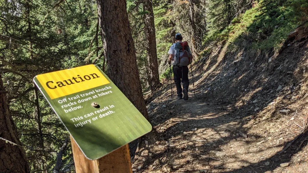
Look for the big information sign just off the parking lot and follow the wide trail as it crosses a gravel road and climbs to a Y-junction. Enjoy the mostly aspen forest and underbrush, which includes a range of wildflowers. In September/October, there’s beautiful fall colour.


Just before the junction is the first of many sets of stone steps put in place as part of the 2021 trail upgrades. The trail going left from the Y-junction is for climbers to access climbing routes on the face of the mountain. Due to the possibility of dangerous rockfall in that area, hikers should head right, towards the eastern shoulder of Yamnuska.

From the top of the steps, the trail gains elevation at a steady pace. Three viewpoint signs along the way indicate good resting/photo spots.


Things to look for: the heart-shaped lake in the valley bottom, the eastern buttress end of Yamnuska (behind you at the third viewpoint) and helicopters (on sightseeing tours or running shuttle service to/from the only heli-hiking area served by the Canmore heliport).


The trail has been rerouted in a few places here, and Alberta Parks has signage up indicating where old (including braided pirate) trails are being reclaimed.

The newer Yamnuska trail sections were still quite obvious as of September 2022: no organic cover from needle/leaf drop.

Raven’s End
Just before reaching Raven’s End, the trail becomes a one-way loop. This is new with the 2021 trail upgrades. The loop is a great turnaround point if you’re just getting started with hiking, hiking with children, have an issue with heights/exposure or mobility constraints. With the 2021 addition of rock “benches” at a viewing loop and other front-end upgrades, it’s also become a more appealing shoulder season/winter hike.

The Raven’s End checkpoint is one of two signs asking hikers to assess their readiness to tackle the scramble beyond this point. Prior to the 2021 trail and signage upgrades, Kananaskis Public Safety and Conservation Officers responded to more than 50 rescue calls per year. These ranged from lost/exhausted scramblers to life-altering/life-threatening injuries and even some fatalities. The checklist is designed to help minimize these kinds of incidents.


The Chimney
This is a very short, well-marked scramble up some boulders, through a narrow slot in the cliff. You emerge at the start of the extended scramble to the summit. Because it’s through a slot, there’s no drop-off exposure. So even those with a fear of heights may want to consider going up through the Chimney before returning to the Yamnuska parking lot. The Chimney is a scrambling “appetizer” – a little taste of what scrambling’s about.


The Chimney is also a bit of a chokepoint, and can get very crowded/backed-up, especially on summer weekends. On a mid-week morning after Labour Day, the only other being we saw here was a squirrel.

Scramble to Yamnuska’s Summit
There is considerable exposure after the Chimney. I’ve (mostly) learned to live with my fear of heights. One coping technique is to ignore the drop off beside me and focus just on the trail and where I’m putting my feet. Another is using my hands more than a person without a fear of heights.

A few short minutes beyond the Chimney is another checkpoint sign. It specifically mentions route-finding, the chain section and weather considerations. We were confident in our ability to reach the summit and then safely descend. And the weather was great.

Thanks to new route markers, route-finding between the Chimney and Yamnuska’s summit is a lot easier than it used to be.


The views get better and better as you scramble onwards.

Between photo stops and scouting ahead for route markers, there are lots of excuses to pause and catch your breath. In the photo below, the notch in the rocks just to the right of my shoulder is where the chain section comes into view.

The Chain
Despite working to manage my fear of heights, the 15-20 meter stretch of ledge where you grip the chain for safety is still a big challenge for me. At the notch in the rocks, I stowed my camera in my pack and removed the GPS and a carabiner from where they hung on my pack’s waist belt. Then I asked Mr. GeoK to go first so I could watch how he covered this stretch. My heart started racing when he bumped his chest-strap mounted camera against the rock face, lost his lens cap and then had to turn back and carefully bend down to retrieve it from the ledge beside his left foot!


One of the most disconcerting things about the chain is that it droops between the 5 or 6 points where it’s anchored to the rock face. So it wobbles around a fair bit. I would NOT want to be doing this with lots of people up ahead/behind, adding more wobbling to the chain. Even without that complication, I have to summon a lot of determination to make it across this piece.
Once you’re across and down, there’s a little wedge between sections of the mountain that offers a peek-a-boo view of the Bow Valley below.

As we continued our scramble to the summit, we heard voices behind us. Another couple was at the chain section and we paused for a few minutes to watch them.

Then, since there aren’t a lot of places to comfortably pass, we continued at our best pace to the summit.

Yamnuska’s Summit
We were shocked that there was no one else at the summit, and got to work photographing the views.


Some wildfire smoke in the air plus a long telephoto lens resulted in moody, blue layer pictures.


The highlight of our time at the summit was meeting a couple of hitherto unmet Canmore neighbours – the couple we spotted at the chains! Celine and Dan run TravelBanffCanada. We had a great chat and hope to hike with them again soon. Fortunately, a few more hikers joined us at the summit while the four of us were chatting over lunch. So we asked one of the new arrivals to take a group photo.

Summit Descent
Celine and Dan had a hard deadline for getting back to Canmore, so they led off. We followed a few minutes later. We kept up pretty well until the start of the West Col Descent. Then they left us in the dust!!! 🙂
The descent from the summit is considerably changed with the 2021 upgrades. The trail from the summit to the West Col has moved upslope. Instead of the ball-bearing pebbles that made the old route so treacherous, the trail is down through loose, sharp rock. It some places it slides underfoot. In others, there are fairly large step downs. We were really glad we hike with poles. I would not want to tackle this stretch without them. Hopefully, with time and more boot beating, this trail section will become a little easier to navigate.


West Col Descent
One last decision as West Col: take the new West Col Descent? or the old scree descent? We did the scree descent back in 2007. It was exhilarating! But Mr GeoK wrecked his hiking boots (no leather uppers). And it was also scary to think about what if you started tumbling? The experience really helped us when we did the Tongariro Crossing in New Zealand.
This time around, we opted for the new West Col Descent. It’s not that exciting. Lots of warning signs, lots of stairs, a few peek-a-boo views of the Bow Valley and Yamnuska, and some butterflies.


In short order, we’d traversed the front of Yamnuska, returning to the first Y-junction.

From there, it’s maybe 800 meters to reach the parking lot, through that beautiful aspen forest. We sure appreciated the play of afternoon sun and shadows along this stretch.


Summary
Distance = 11 km loop
Elevation gain = 974 meters total (882 net)
Time = 5 hrs 30 minutes including 2 hrs 30 minutes for photography and lunch
This is a half-day scramble about an hour from Calgary, so expect the route to be busy, especially on summer weekends.
OPTION: The out and back to Raven’s End is a good option for families, those just getting into hiking, and those looking to maintain conditioning during shoulder seasons. Distance = 8.5 km with a total elevation gain of 534 meters.
This is a great write up and really helps us plan our hike to Yam in the middle of August. Is it common or possible to hitch a carabiner to the chain as you traverse across that ledge ? I don’t have a fear of heights but rather not take any risks. Comments would be much appreciated. Thanks
Hmmm, I’ve never used a carabiner except on the Mt. Norquay Via Ferrata experience. Because it’s a chain, and not a wire, I would think you’d need a fairly large carabiner. Also relevant, the chain is not one uninterrupted length. It’s bolted in 5 or 6 times altogether, so if you’re looking to avoid risk, you’ll probably want two carabiners attached to your harness so you can attach to the next section before detaching from the completed section. We’ve hiked Yamnuska twice over the years, and didn’t notice anyone clipping on either time – but that’s just random observation, so maybe some people do. Hope you have a great experience at Yam in August.
This is the best review of Yamnuska I have ever read! The narrative describes all parts of the trek very well from getting there to the many choices along the trail. The part that sets your reviews apart are the links and the accompanying pictures and videos which truly capture both the beauty and the difficulty on this particular trail. I remain ever grateful that you take the time to share your adventures!
This is the best and most detailed description of the Yamnuska hike/scramble I have ever come across. It solidifies my wavering decision to never summit and do the loop, but only go as far as Raven’s end. Watching Kyle come across the chain section and the narrow section after the chains…. that is definitely not for me. Had a wonderful time yesterday on the Buller Pass trail. Larches were actually very colourful up there on Sat., Sept 25th.
Well done my friends. Great writeup Mrs