The Golden Circle tour is one of the most popular day trips with visitors, covering a 300 km loop from Reykjavík into central Iceland and back. Whether you join an organized bus tour, hire a super truck and guide for the day or drive the route in a rental car, the three “must see” locations are Þingvellir, the great Geysir area, and Gullfoss. Other possible stops, depending on the tour company or your own preferences include the implosion crater Kerið, Langjökull glacier (either by super truck or on snowmobile), Hveragerði greenhouse village, Skálholt church, and/or a geothermal power plant at Nesjavellir or Hellisheidarvirkjun.
Our personalized Golden Circle tour was more of a line tour, since that was the logical way to end our drive across the Kjölur plateau via route F35.
Our first stop was a super truck drive onto Langjökull glacier. Watching the GPS map as Ragnar drove onto the glacier, it seemed to me the glacier has receded quite a bit from whenever the map is dated. We took full advantage of the privilege of being there by stopping the truck and getting out to explore a bit on foot, always under the watchful eye of our guide. It was pretty cool (pun intended), but I enjoyed our heli-hike at Franz Josef glacier in New Zealand more.


Our second stop was Gullfoss (Golden Falls) on the Hvítá river. What’s unique about Gullfoss is that the river drops into a crevice about 20 m wide, 32 m deep and running 2.5 km perpendicular to the flow of the river. As a result, when one first approaches the falls, the crevice is obscured from view, creating a temporary illusion that the river simply vanishes into the earth. I didn’t want to mingle with the crowds of people (this is one of Iceland’s most popular tourist destinations), so I walked a short distance upstream while the guys took photographs from the crowded overlooks.


Next, we stopped at Haukadalur geothermal area, site of geysers and other geothermal features including little hot springs, mud pots and fumaroles. The most well-known (and largest) geysers are Strokkur and Geysir (which gave others their name). Since we’d explored two other geothermal areas in the past 36 hours, we opted to limit our visit to watching and photographing Strokkur, which quite dependably erupts every 5 to 10 minutes.


")
Our next stop was a quick one, along the shore of Þingvallavatn, Iceland’s largest natural lake and a popular scuba and snorkeling destination.

We allocated considerably more time to our next destination: Þingvellir. It’s a UNESCO World Heritage Site on account of the fact that it’s the site of the first parliament in the world. Established in 930 and continuing to meet until 1798, the Althing was an open-air assembly representing the whole of Iceland that met two weeks a year. The assembly set laws and settled disputes. Sentences were carried out there and then. The Althing has deep historical and symbolic associations for the people of Iceland and we noticed that visitors were a bit more respectful and introspective at this site than they were at many others in Iceland. A major bonus consideration for us is that Þingvellir is also a great spot to observe the mid-Atlantic Ridge (i.e. where the North American and Eurasian tectonic plates are slow separating).


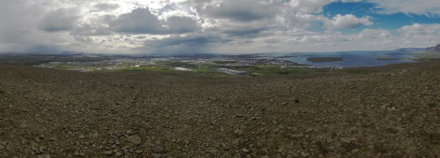
Finally, just six or seven km from Reykjavík, Ragnar took us up a rough 4×4 track to a hill overlooking the city. While I searched for a geocache, Mr. GeoK made this beautiful panorama of the capital and its surroundings.