
The Green Monster is our favourite winter hike so far! With at least a half-dozen beautiful frozen waterfalls between the trailhead and the Green Monster, this trail is for winter adventurers, including photographers, hikers, snowshoers and ice climbers.
We found the out-and-back trail to be well-packed, with one challenging stretch and one very short section in avalanche terrain. MICROspikes were essential, but we didn’t need our trekking poles. Proper winter hiking gear, including extra layers, is essential to ensure a safe and comfortable outing.
Getting There
There is no shuttle bus service through Kananaskis (although given the high number of K-Country visitors, that may change at some point in the future). So you’ll need to drive or car pool to do this hike.
From the TransCanada Highway between Calgary and Canmore, head south into Kananaskis along Highway 40. Once you pass the turnoff to the Kananaskis golf courses on your right, start watching for the Evan-Thomas Day Use Area on your left. We clocked it at 25 km from the TransCanada.
REMEMBER – a Kananaskis Conservation Pass is required to park in Kananaskis Country. Day/annual passes can be purchased online or at the Barrier Lake Information Centre adjacent to Highway 40. Cellphone reception can be a challenge in the Canadian Rocky Mountains, so don’t wait until you’re at the trailhead parking lot to look after this requirement.
The Evan-Thomas Day Use Area parking lot was empty when we pulled in at 8 o’clock on mid-March morning. We’d seen photos of the Green Monster all over social media, so expected it could get fairly busy, even mid-week.
A four-stall pit toilet facility is located just off the parking lot. One stall was unlocked the day we were there.
The trail head is the “Old Baldy” trailhead, off the southwest (right hand as you’re driving in) side of the parking lot.
Hiking In
Head out along the wide “Old Baldy” trail. NOTE: one side of the trail is track set for cross-country skiers. PLEASE do NOT walk on the ski tracks. And if you’re hiking with a dog, this is a great opportunity to practice keeping your dog leashed on your left hand side! 😉

The trail makes a sharp left about 50 meters along. Keep the groomed ski trail on your right for about 1.6 km. Stay left at the first unmarked junction (about 1.1 km from the parking lot), or you’ll end up at Wedge Pond.
This front section is pretty boring. HIghlights include an assortment of signs…

…and peek-a-boo views of mountains further south along the Kananaskis Valley.

Drop Down to Follow Evan-Thomas Creek
At the 1.6 km mark, turn right at the trail fork. Continuing straight could eventually get you close to the Green Monster via the other arm of the Evan-Thomas Loop, but you’d miss several of the scenic highlights and would have to take the correct (presumably unmarked) trail junction to get there. Or you could just pass it by on your way to Old Baldy.
Cross the footbridge installed after the 2013 flood…


…and then drop down into the wide, flat valley resulting from the 2013 flood. Some trail descriptions say to watch for a picnic table here, but we didn’t see one. We did spot the old footbridge, washed downstream during June 2013 flood.

Look upstream, to the left, and follow the well-packed trail as it starts to gain a bit of elevation, following Evan-Thomas Creek into the canyon, which starts out quite wide. From here, it’s about 1 km to Chantilly Falls, the first of the frozen waterfalls.

We hiked in shade, pretty much all the way to the Green Monster. Extra layers are essential for comfort here.
Chantilly Falls
As the trail crests a slight rise and turns to hiker’s left, look across to the slot for the first major waterfall along the way. We believe this is Chantilly Falls. It was in shadow both times we passed it (makes for white balance challenges), and partially obscured by trees. Mrs. GeoK approached the base, but quickly decided to move along to better photo opportunities.

Canyon Narrows
To this point, the forest on hiker’s right hides the fact that you’ll soon be hiking beside a cliff (estimated height = 35 meters) demarking the east edge of the Mackay Hills. The canyon narrowed somewhat, just as the sun lit up the cliff face, making the distinction between with east and west sides of the canyon even more dramatic. And the sun made it easy to see the sedimentary rock layers up the cliff face.


Moonlight Falls
This is also where we spotted a hanging frozen waterfall just a few minutes further along. A zoom lens gave us a good preview.


It’s easy to imagine this icefall lit by a full moon.
We opted to follow the short, steep, boot beaten path up to the base of the falls.


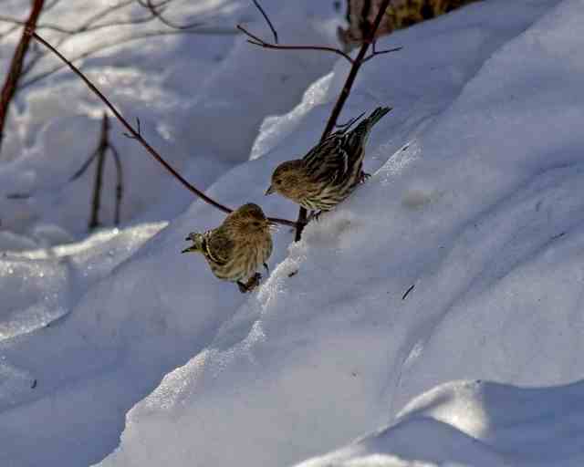
A couple of Pine Siskins kept us company as we stared up at the wall of icicles.
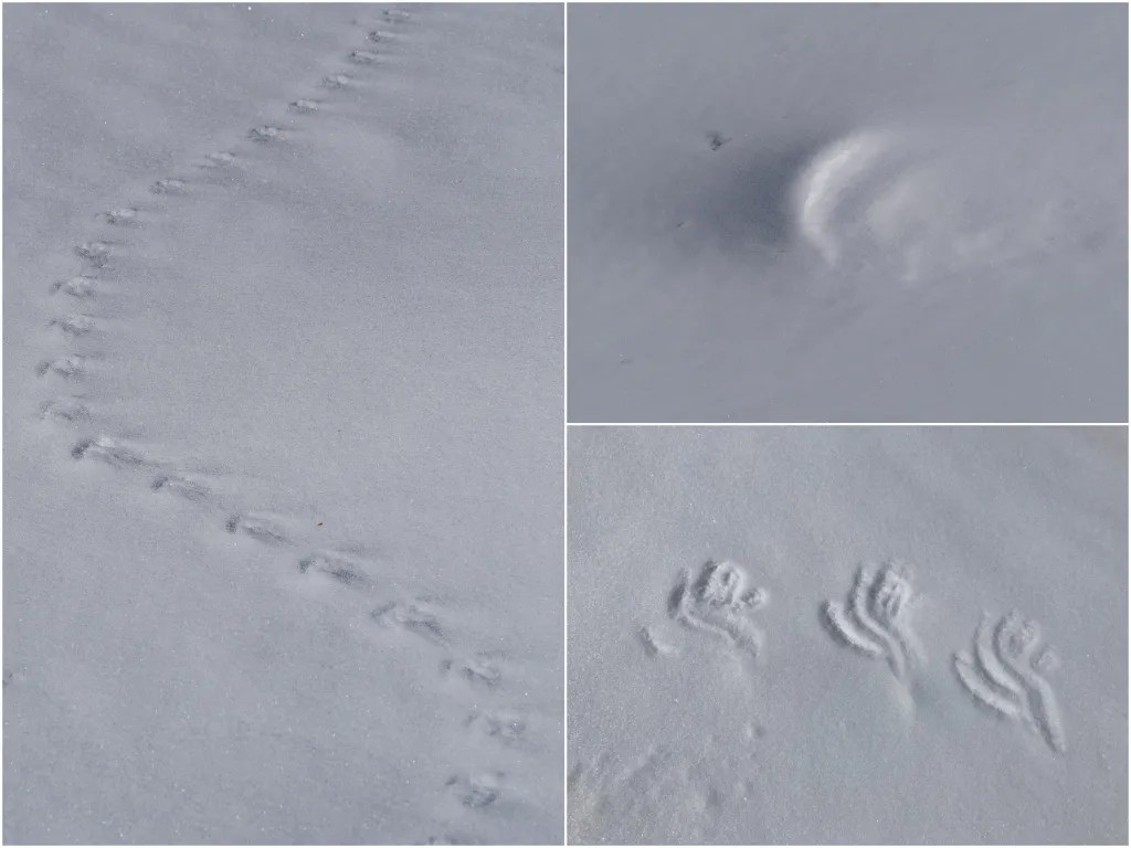
Play of Light and Shadow on Snow
Back on the main trail, we noticed the sun was finally high enough in the sky to cast very interesting shadows on snow shapes. We took quite a few light/shadow/snow photos over the remainder of the hike. Here’s a handful…


Mr GeoK spotted one more waterfall before we reached the chain/rope section, but I totally missed it.

Chain and Ropes
At a certain point, about 5 km from the parking lot, the canyon narrows to an impassable choke point. It’s time to go up and around, making use of a short section of chain and some knotted ropes installed by some of the many ice climbers that enjoy this area. To get a better sense of this section, check out Mr GeoK’s Relive video recap.


We found MICROspikes very helpful here on the way in, but not that helpful on the way down (on the bare rock section). There is some exposure, but not as much as on the chain section of Yamnuska. Nor is the ledge as narrow. As someone who’s been working on her fear of heights for years, I found this section very manageable.
NOTE: shortly after the chains/ropes section, there is one very short stretch that crosses the bottom of an avalanche chute. Cross this section quickly, and one at a time. Always check avalanche conditions before heading out and take as much avalanche safety training as you can.

More Waterfalls
In the final section of slot canyon, we passed more big frozen waterfalls. Ice climbing resources on the internet give names like Slurpee, Rehab Wall, Good H’evans Thomas and Fun & Fitness. I have no idea which is which. More than once, one of us exclaimed “That must be it!” only to realize that it wasn’t the Green Monster quite yet.


Almost There

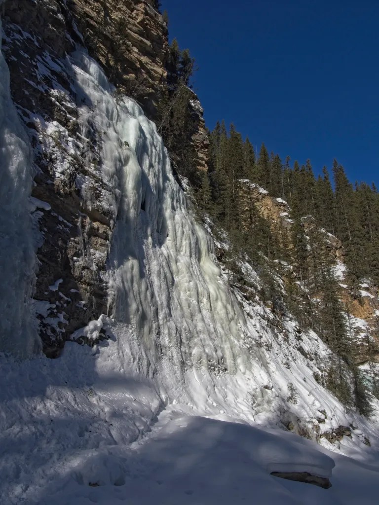
Green Monster
We enjoyed the company of the Green Monster for at least half an hour. There was no one else around. We took turns going in behind the frozen waterfall to take photographs. And we went a little further upstream, to yet another waterfall where the trail came to an abrupt end.


Inside the Green Monster


Hiking Out
Our hike out was much faster than our hike in, taking just an hour and 45 minutes. Mr GeoK was on a mission to get home in time for a webinar.
Of note: 1) we saw 16 people along the trail as we hiked out, so I guess a couple of hundred people or more hike this trail on prime winter weekends; and 2) the light was way different hiking out. So the waterfalls looked very different.


We found the knotted ropes/chain section more challenging hiking out than hiking in. But you gotta do what you gotta do!


At one point, I stepped off the trail to change my angle for a photo I wanted to take. Big mistake! I sunk up to mid-thigh.

We saw a fair bit of snow graffiti along the way. Most of it was positive…joy, beauty, this way to happiness. But one saying brought back memories from hiking Jura Creek with our teenagers way back when. 🙂

Our top speed on the way out? Seven kph – Mr GeoK really wanted to watch that webinar! 🙂

Mother Nature gifted us a bonus back at the parking lot…a small flock of Rosy Crossbills.

Summary
We rate this a “can’t miss” winter hike and plan to do it again…and again! It’s straightforward, with minimal elevation gain. The main challenge is the chain- and rope-assisted “up and around” the canyon chokepoint section. Crampons, MICROspikes or something similar are essential. Wait at least a couple of days after a major snowfall for some other energetic soul with strong route-finding skills to pack in the trail. If you want to see ice climbers, you’ll probably have better luck going on a weekend.
Distance = approximately 12.5 km (our GPS said 15.2, but there’s a lot of signal bounce in the canyon so that’s on the high side); 11.6 km without the side trip to the base of Moonlight Falls
Elevation gain = approximately 330 meters (160 net)
Hiking time = 3 hours 15 minutes plus time for photography (total 4 hrs 40 minutes for us)
This route also shows as a summer hike on AllTrails, variously named Evan-Thomas Creek to Falls, Evan-Thomas Creek to Cascade Falls and similar. A scan through the photos posted to AllTrails suggests that somewhere around 90% choose to do this as a winter hike.
We chose not to do the Evan-Thomas Loop option this time around, thinking the up-close views of waterfalls in the canyon likely to be more picturesque. But it’s an option to keep things fresh on a subsequent trip to the Green Monster.
Pingback: Where Will You Go? - Out & About with the GeoKs