
When our kids were young, the trail to Chester Lake was a family favourite. It’s a great shoulder season hike, can be done on snowshoes in the winter, and has a lake for skipping stones, dipping toes or watching fish rise. It’s pretty easy, with about 400 meters elevation gain over 10 km or so (return). And there are a few options to extend a family outing past the lake: a loop around the lake, the Elephant Rocks (this was our kids’ favourite), or continuing up to Three Lakes Valley (which is generally less crowded and has lots of fossils to look at).
So I was kind of shocked when I realized the last time we hiked to Chester Lake was in 2008, when the GeoKids were 8 and 12 years old! We did go as a family once after that, on New Year’s Day in 2013.
I’d made arrangements to hike the new and improved Ha Ling trail with a friend, but when a closure notice went up due to a cougar incident, I quickly agreed to Chester Lake as our Plan B.
Getting There
The Chester Lake trail is located along secondary highway 742 (aka the Smith Dorrien Trail), a gravel road that heads roughly south from Canmore’s Nordic Centre Provincial Park. As expected, we drove on everything from pretty smooth, hard-packed dirt/gravel to washboard ruts to potholes filled with muddy water. About an hour and 10 minutes after leaving Canmore, we pulled into the well-signed Chester Lake parking area.
And what did we see? Two moose! They looked to be a mother and calf and mama moose was very interested in my friend’s car! She ended up setting off the car alarm to scare it off, so we could get our packs and urban poles from the back!


The Trail
Watch the signs. There are trails for cross-country skiing, snowshoeing, a connector to the Burstall Pass trail and a connector to the High Rockies Trail all within a few hundred meters of the parking lot.
The hiking trail sets off through a mostly spruce forest, gaining elevation at a slow and steady rate. The trail is reasonably wide, comfortably accommodating two friends with lots to talk about! 😉
We’d packed snowshoes, but left them in the car after checking the conditions at the trail head. We also packed MICROspikes (or equivalent), and ended up wearing those most of the hike.

About an hour from the parking lot, the trail emerges from the forest. Thanks to a broad meadow, there’s a bit of distance between you and Mount Chester. I love being in the mountains when there’s just enough snow to highlight all the character lines: meandering streams, sedimentary layers and folds, drainages and wildlife trails.

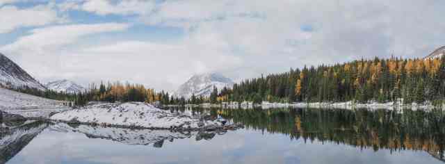
There are some larch around Chester Lake. They were a little past prime, but we enjoyed the sprinkling of gold around the shoreline. The skiff of ice on part of the lake added to the strong impression that Kananaskis Country is deep into the fall season.

We reached Chester Lake well before 11 o’clock – too early for lunch! So we set counterclockwise around the lake.

We took our time, enjoying the scenery and bit bit of exploration, including this little “not quite” an island at the north end of the lake (where there’s also a pretty little waterfall). The reflections on the still surface of Chester Lake caught my attention here.

It was still too early for lunch when we reached the trail branch that goes to Elephant Rocks and then continues on to Three Lakes Valley. We followed the trail as far as it had been packed down by someone on snowshoes and then turned back.

Thanks to my friend’s solid photography skills, here’s one of me approaching Elephant Rocks on the way back. That’s Mount Chester, with the vertical sedimentary layers, behind.

The Elephant Rocks looked pretty amazing dressed in a thin covering of snow. We got to talking about them. Are they glacial erratics? Or rock fall? Maybe I need to take a geology class or two! Or maybe you know? If you do, please leave a comment to fill me in.

We stopped at one of the log bridges near the lake for a light lunch (or hearty snack, depending on your perspective). The wind was picking up and the clouds were thickening as we headed down. We both paused for a few minutes beside the pretty meadow, just enjoying the scenery and being in the great outdoors.

The big wildlife treat on the way down was a healthy looking spruce grouse. He was pretty indifferent to us. We stopped quite a ways off when I first spotted him, but he tolerated us getting within about 5 meters before he finally moved off the trail so that we could continue past. Probably the most interesting behaviour was when he ate some snow.

Back at the parking lot, it was clear that mama moose had returned and given the car a pretty thorough washing. There was a note under the windshield washer. Other hikers had taken photos of the car wash in progress, and then added that a conversation officer had come along and fired a flare gun to scare the moose off – for the safety of the wildlife and human visitors. Maybe that’s the shot we heard when we were up at Chester Lake. Do flare guns make a shot noise?

SUMMARY:
Total hiking distance = 11.6 km
Total elevation gain = 447 meters (371 net)
Total hiking time = 5 hours 30 minutes (including 2 hours lunch and photography)
Thanks for this informative report of our hike to Chester Lake enhanced by our combined photos!
Thanks for sharing your photos! And for driving! And for the great conversation! Let’s do Ha Ling ASAP.